Concrete Batch Plant

37
Photo: A. E. Turner, USBR
9/15/1958
Courtesy of the Legate Family

Here’s a shot looking down on the conveyor belts that transported the gravel underground to the batch plant. It’s dated 9/15/1958. There is a hand-written caption on the back that reads, “Concrete batching plant and concrete aggregate piles. Aggregate goes to tunnel and conveyor belt below piles and took to top of plant.” If you enlarge this and look close, you’ll see a gravel truck approaching what I believe is the dump hopper.

On the right side of the photo near the top, you can see where the canyon wall has been excavated in preparation for the dam. You can also see the spillway cut out on the far side of the canyon. You can also see the anchor point for the bridge arch on the Page side. Just to the right of this picture is the present day Visitor’s Center.

You can also see the footbridge and its shadow being cast down the canyon wall near the center of the picture.

-Mike

1958 Glen Canyon Dam Preparation

Photo: A. E. Turner, USBR Courtesy of the LeGate family.
Photo: A. E. Turner, USBR
Courtesy of the LeGate family.

This photo is dated 7/8/1958. The back reads, “Foot bridge. The diversion tunnel inlet can be seen at bottom of canyon on right.”

As I scoured this with my handy-dandy magnifying glass, I noticed about a dozen people walking across the footbridge. As was stated on the back of the photo, you can see one of the diversion tunnels at the bottom of the canyon. These were used to divert the Colorado River water around the dam site during construction.

In the distance you can see a very dry Wahweap Bay and Castle Rock. It looks like this picture was taken from on the Beehive. It would be cool to find that spot and take another picture today of this same angle. This may have been taken before they sheered off the side to make room for the railways that supported the cable cranes. And you thought the flattened side of the Beehive was there to make room for the Visitor’s Center, didn’t you. The dam sight is just to the right of this picture. Stay tuned…

-Mike

Early Page

Page Arizona, 1957-58. Source: USBR.
Photo courtesy of the LeGate Family

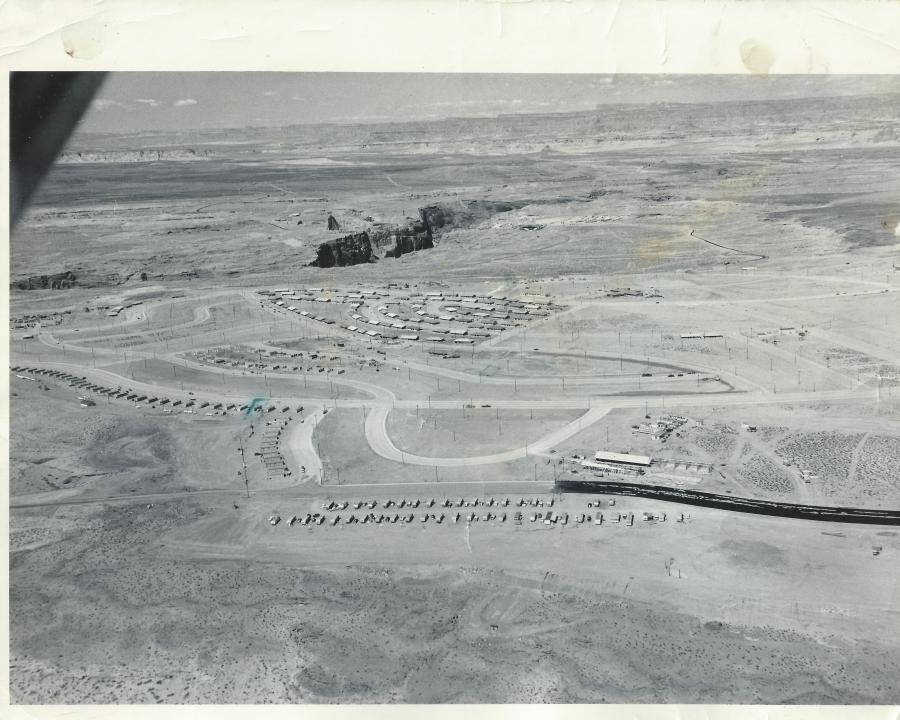
This fantastic aerial shot of Page is undated, but I think it’s safe to place it in the 1957-58 time frame. The original photo is an 8×10 with the following hand written on the back by Gene C. Legate (unedited),

“Gov’t houses under construction. Ours [Legate’s] is 4th house from right end of the line of houses which extend from middle of picture to left toward middle of picture. Other place marked is where we’ll move to shortly. Black road is fresh oil which is put on before asphalt is placed on it. The first 100 houses shown are near completion. The second 100 are now about finished and are in the two blocks below first 100. Dam site in exposed canyon. Temporary school at lower right under construction.”

There is a lot going on in this picture that I would like to talk about. Let’s start at the bottom of the picture. I don’t remember the two lines of mobile homes at the bottom along 7th Avenue (now Lake Powell Blvd), but they are sitting on the approximate location of the Catholic Church. I think there’s a tennis court there now too. The temporary school buildings across the street from the mobile homes referenced on the back of the picture, became the X and Y buildings where I started 1st grade in Mrs. Frye’s class. I have a street-level picture of those buildings, and a story to share with you at a later date. The circular road next to the X and Y buildings was the drive through where buses and parents would drop their kids off for school. I remember it well. That road’s been gone a long time and is now baseball fields, I believe. The high school football homecoming bonfires used to be held in that area.

The row of buildings along the street next to the drop-off loop, that continue on to South Navajo Drive, were the transit (transa?) houses. I think these were originally put there as temporary housing for some of the USBR employees. Someone help me out here if you have more info for us. What I do remember is that they were a bright pink color and they were there for years. Do you see the green pen mark next to the 4th one along Navajo Drive? That is the one referenced in the description on the back of the picture as being where the LeGate family lived for a time. It’s hard to see, but if you enlarge the picture, you’ll see a green square drawn on Cedar Street, also referenced on the back of the picture as “the place…we’ll move to shortly.”

Continue reading →

The Mother Lode

I talked with Gene LeGate late last week and he loaned my a bunch of pictures that had been in storage for use on this site. Gene and I started first grade together in Page, so there is some history and shared memories there. In all, he loaned me just over 120 pictures, almost all of which are 8 x 10 black and whites dating back to the late 50s.

I’m excited to share these with you. So far, I’ve scanned about half of them and I hope to finish up this week. Since they’re so large, I’ve decided to give the site a facelift by installing a new template that is wider and takes up more of the screen.  That will allow me to keep the pictures closer to their 8×10 original size.

Did I mention that these pictures are amazing?

Later,

Mike

This is a Dam Site

GCD 1961
Glen Canyon Dam 1961.

This shot was taken from an old Page High School yearbook and is a downstream look at Glen Canyon Dam in 1961. My apologies for the page crease down the middle. Pretend it’s not there.

It looks like the footbridge is still there. If you enlarge this picture and look close, you can see the posts on either side of the canyon and each end of the bridge. You can also see the shadow it’s casting on the canyon floor just upstream of the dirt dam that’s diverting the river water.

The original visitor’s center is to the left of the bridge on US 89. That building was later moved into town and became the LARC Center, located next to the football field at the corner of South Navajo Drive and 7th Avenue (now Lake Powell Blvd).

The town of Page is clearly visible in the upper left of the picture. The golf course and Country Club can be seen near the top right of the picture, on the far end of the canyon. The small body of water on top of the canyon next to the golf course was the old waste water treatment pond. That’s all I’m going to say about that.

I don’t remember what the large building on the left was, next to the highway. I remember it being there, but I don’t remember what it was. If you can add more info about it, please comment below. The “Add a Page to your Trip” road sign that I mentioned in my first post was located on the highway turnoff to Page at the upper left of this picture.

I remember this stage of the dam construction well. It seems like we ended up out there almost every day, watching the construction progress. At night, there was a flashing “Cocktails” sign on the rim of the town that belonged to a bar on Vista Avenue. I was too young to go bar hopping, but I remember that sign well.

-Mike

1958 Post Office

image
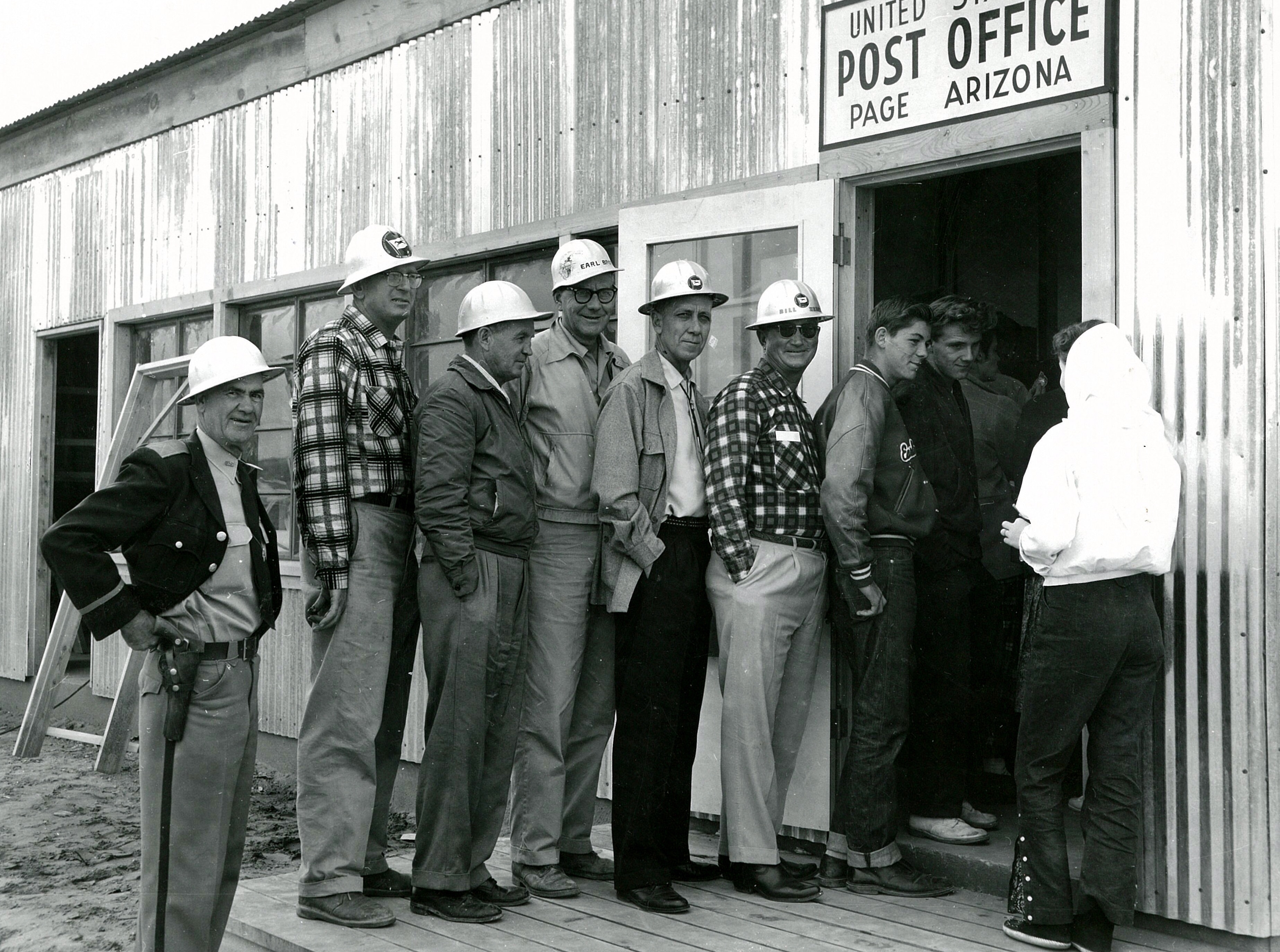
Page Arizona Post Office 1958. Source: LeGate Family

This amazing picture was sent to me yesterday by a friend (thank you Gene!). I don’t know who took it or why, but it’s one of my favorites. It’s the Page Post Office in 1958. This was taken 1 1/2 to 2 years before we moved there and I don’t recognize anyone in it. I think it’s interesting that the young guys are talking to the girl, but the older guys are all about the camera, except that one guy. There’s always that one guy.

This building was located next to the USBR warehouse on North Navajo. across the street from present day Stromboli’s. I am curious to know why there was such a line out the door on this day. Nobody seems to have anything to mail. Maybe it was a rush on forever stamps or maybe there was free wifi.  But I doubt it.

-Mike

Econ-O-Wash

Capture2
1973 Yellow Pages ad

I found a copy of the 1973 Yellow Pages so I have a new category to post these ads in. I’ll be posting these old ads from time to time.

I’m posting this one first because it’s special. First, it reads, “Add a Page to your trip.” I’m relieved to see I’m not the only one who read that old sign. If you’re wondering what I mean, check out my first post, Add a Page To Your Trip.

Another reason I’m posting this one first is because it was one of my first full-time jobs. Yours Truly was one of the truck drivers that picked up and delivered laundry to the boarding schools on the reservation and brought it back here to be laundered. I worked for Al and Sandy. They were great people. I wonder if they’re still in Page?

But the big reason I’m posting this ad first is because I lived here for a while. Yes, it’s true. I lived at the laundromat. At least my clothes were always clean. Drive down to Vista Avenue and check this place out. It’s kind of an “L” shaped building with the corner of the “L” built out toward Vista Avenue. That was my apartment. Initially, it was a beauty salon, but eventually became my home sweet home in 1972ish for several months.

-Mike

More Dam Construction

damleft 1962
1962 Dam Construction

My last post showed a look at the right side of Glen Canyon Dam during construction in 1962. In the name of leaving nothing undone, here the other half of the picture showing the left side.

This is a spectacular shot looking upstream at what is mostly under water now. The cement plant is visible on the left behind the bridge just below where the visitor’s center now stands.

Do you see the black line across the bottom of the canyon and up the canyon wall on the right? I don’t know if that’s just something on the picture or if it’s a shadow from the original footbridge. I’m not sure when the footbridge came down. Was it still there in 1962? Anybody? If you know, feel free to chime in.

You can see the water that’s being diverted around the dam at the bottom left of the picture. I think it was being diverted on the other side too.

Dam Construction

Early 60s Dam Construction
1962 Dam Construction

This is a great shot of Glen Canyon Dam under construction from 1962. I don’t remember where I got this picture but it’s one of my favorites because this is how I remember the dam. I spent a lot of time on or near the bridge during this time, watching the dam go up. I must have rode my bike out there a lot with friends just to hang out and watch the construction. It never got old.

From the bridge, the trucks and workers below looked like toys. I remember that elevator on the wall of the canyon. I would watch it carry workers up and down for what seemed like hours. It probably was hours. That was one positive about growing up there. My feet would hit the floor in the morning and I was gone all day.

To the right of this picture, just downstream of the bridge, was the original visitor’s center and lookout. The road down to the old lookout is still there, as is the lookout and parking lot, if anyone’s feeling adventurous.

-Mike