First Things First

First Buildings
Photo: USBR, date and photographer unknown.
Source: Terry Edwards

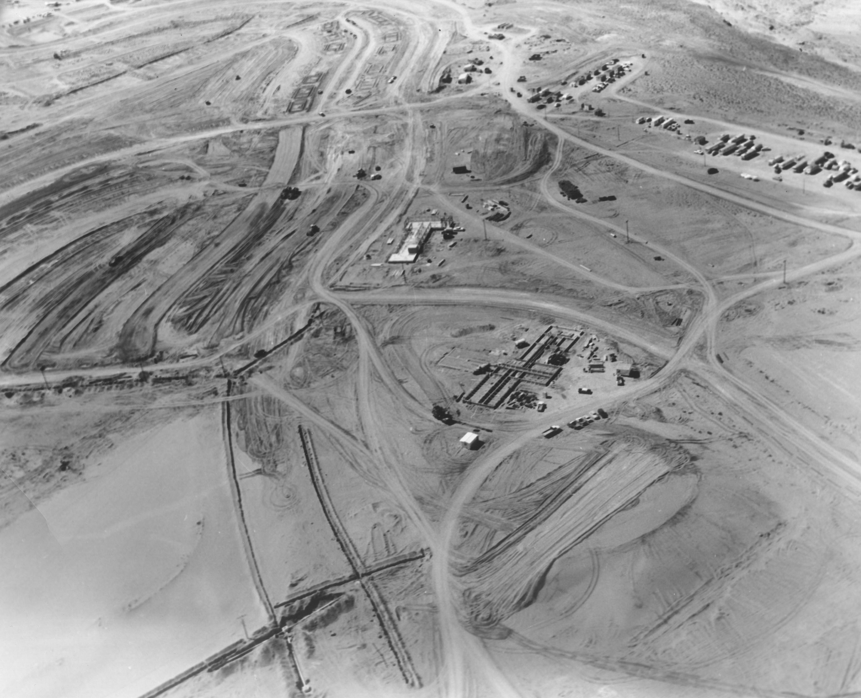
It took me a few minutes to figure this one out, but I eventually did. I’m not the sharpest knife in the drawer, so that explains a lot. This first pic is an early shot of two of the first buildings that went up in Page, if not THE first two.

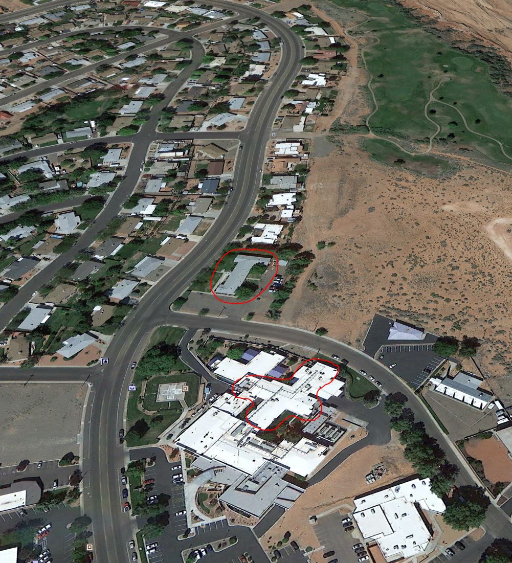
There weren’t any landmarks in the picture to go by, so it kind of leaves you on your own. Give up? This is the corner of Vista Ave and North Navajo Drive. The larger building is the hospital and the smaller building originally served as the USBR admin building. It’s been a number of other things since then. I talked about it and shared a really nice photo of it with you in a previous post [HERE]. Be sure to click that link if you haven’t already seen it. It’s worth the click! The dirt road between the two buildings is Vista Ave. The nicely graded road to the left is Gum Street. For reference (and because I have awesome moments) the picture below is how that same area looks today. I rotated it to match the angle of the picture above as much as possible, and I circled the same two buildings. The hospital’s grown from it’s original size, so the area I circled is the original footprint of the building.
Page Now
The same two buildings are circled in red.

Enjoy!

-Mike

Route 66: Season One, Episode Nine

Route 66
A scene from season 1, episode 9 of Route 66 filmed in Page.
Photographer and date unknown.
Source: Terry Edwards

There were a lot of movies and a handful of TV episodes filmed in the Page area in those early years. The ones that stand out to me while growing up there were The Greatest Story Ever Told, Planet of the Apes, Easy Rider, and later, The Outlaw Jose Wales. But who could forget the epic TV series, Route 66, starring Martin Milner of Adam-12 fame and…. that other guy. What was his name? Oh yea, George Maharis. In the series, they were Tod (with one d) and Buz (with one z). They drove the old Route 66 in that cool Stingray and did things.

Season 1, episode 9 was filmed in Page. The first picture below captured the filming of one of the scenes at or near the airport. The cool Stingray is sitting there, waiting for action. This episode aired on November 2, 1960 and was entitled, Layout at Glen Canyon. If this scene was shot at the airport, I lived a stone’s throw from where it was filmed. Check it out…

I grabbed the screen shot below from the IMDB web site when I searched for Route 66. It filled in some of the gaps for me. Unfortunately, I can’t find that episode anywhere. Netfix only has the first two episodes of season one. I sure would like to watch it. If any of you come across it, please let me know.

I know I said I wasn’t going to blog anything here until after December, but this was too good to wait. Enjoy!

-Mike

The Leap to Facebook

Well, I did it. I made the leap to Facebook! If you’re on Facebook, please hook up with me there too and feel free to like my page. Send your Facebook friends there too. I just built the page today, but all of my blog posts are there. I’m using Facebook to mirror this site, not replace it. I’ll still be posting all my stuff here and mentioning my posts there. Check it out and jump right in:

https://www.facebook.com/pageaz

-Mike

December Break

Photo: A. E. Turner, USBR
12/16/1961
Source: The LeGate Family

Hey all, I’m taking a break from blogging for the month of December and I’ll pick back up again in January. I want to leave you with a Christmas picture of early Page. Check it out…

There isn’t anything written on the back of this picture except the name of the photographer and the date. I don’t know who that was dressed up as Santa. At first, I thought this was in the school gymnasium, which would have been new that year. But the more I look at it, I think it was somewhere else. That door in the background has a big window in it and the doors to the gym weren’t like that, at least not that I remember. I also thought at first that those were bleachers along the back wall, but I think it’s only a bench of some sort. Does anyone know what building this was in? There are two faces that I recognize, but I don’t have names to go with them.

How about you? Do you see any familiar faces in this shot? If so, let me know.

Enjoy your holidays and I will “see” you next year!

-Mike

Something You’ll Only See Here

52
Photo: A. E. Turner, USBR
Undated
Source: The LeGate Family

This photo is undated, but I think it must be 1957ish. The handwritten caption on the back reads,

“In bottom of canyon upstream from bridge. Concrete form for diversion tunnel shown here. To the bottom left is tunnel (mile plus long) which will connect the power house to top of canyon wall and to Page.”

There are a couple of things that need pointed out on this photo. The writing I cited above mentions a diversion tunnel and a tunnel that goes to the top of the canyon wall. Those are two different things. The opening mentioned on the left of the picture is the bottom of the tunnel that runs from there to the top of the canyon and comes out behind the old Country Club an golf course. That tunnel is still in use. The lower opening to the tunnel that you see in this picture is now on the downstream side of the dam and comes out near the power house. The next time you’re there, look down and you’ll see it. It’s interesting that the back caption says this tunnel WILL connect the top to the bottom, as it was still under construction at the time of this photo.

The concrete form mentioned in the picture is the round object on the right. There were two diversion tunnels that re-directed the Colorado River water around the dam site during construction. In future posts, I’ll be sharing some pictures with you of construction inside those diversion tunnels, as well as the upper spillways which connected to the diversion tunnels.

Notice the roadway in the center of the bridge and the road protruding out from the canyon on the right side. The present-day visitor’s center is located on the right side of this picture by the road. Also notice the netting that hung off the bottom of the bridge to catch falling workers and material. The cables that spanned the canyon are clearly visible and it looks like there is another roadway support being set at the time of this photo. This view is long gone!

-Mike

A Tunnel Runs Through It

Photo: F. S. Finch, USBR
4/27/1957
Source: The LeGate Family
The back of the photo reads, “Small tunnel in keyway. Used for what I don’t know.”

These are great shots of some unidentified workers in random tunnels in the rock around Glen Canyon Dam. The captions below the pictures tell you what was written or stamped on the back. I don’t know what these tunnels were used for, or if they’re still there. Enjoy!

Photo: A. E. Turner, USBR
1/30/1958
Source: The LeGate Family
The back of this photo simply reads, “Tunnel in Keyway.”

-Mike

That Was Then; This is Now

Page Town Site
That was then.
Source: Dugan Warner.
The photographer is unknown, but this is most likely a USBR photo. It’s undated.

I have to confess, I spent a lot of time pouring over this top picture and then I had this brilliant idea to grab a current day photo and compare. Yes, I have moments of brilliance. But they’re short lived.

This post has two photos. The one above was then and the bottom one is now. The top picture was taken before time began. That’s an exaggeration, but it’s not too far off. It’s a high altitude photo of the Colorado River at the Glen Canyon Dam site. There is nothing there but a muddy river. The soon-to-be city of Page is outlined in the dotted area. Wahweap creek is visible (and empty) at the bottom right. The beehive is plainly visible, but this was clearly taken before any work on Glen Canyon Dam or the city of Page had begun.

When you’re done with the top photo, look at the “now” picture below for comparison. I want to thank Dugan Warner for supplying the top photo to me so I could share it with you. Enjoy!

-Mike

Capture
This is a present day look at the same area.

Highscalers

climbers
This photo is undated but is in the late 1950s. The photographer is not identified.
Source: Dugan Warner

One of my first posts on this site was of a couple of highscalers belting off before going over the edge of the canyon. Here’s another one for your visual enjoyment! I’ll make a few comments below.

I don’t have the date this picture was taken, or any information about the photographer, but it was most likely a USBR photo. I can’t imagine who else would have gone over the canyon wall with these guys to get this shot. If you zoom in on this picture, you’ll see that they are using a drill of some kind to bore holes for anchors into the canyon wall. A square end plate was attached to the anchors (if that’s what these holes were for) to strengthen the sandstone wall and help keep it intact.  These could have been something else, but that’s my best guess. They’ve already anchored several that look ready to be finished. Notice the 2 x 12 platforms – one below them and the other nearer the photographer. The photographer’s probably standing on that one.

This picture was taken from the Page side of Glen Canyon, looking downstream. Glen Canyon Dam is behind the photographer. A special thanks goes out to Dugan Warner for getting this picture to me.

-Mike

7th Avenue From The Air

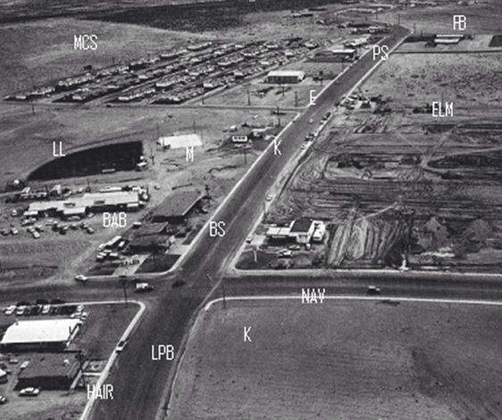
Here’s an aerial shot of Page giving us a good look at 7th Avenue (now Lake Powell BLVD) and some of the early town construction. It’s undated, but 1960-61 is a good guess. I’ve had this photo for a long time and I don’t remember where I got it for sure (maybe Brian Keisling) and I’ve never known who took it or who marked up the different locations. But those are helpful, so let’s run through them.

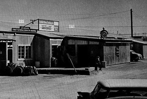
LPB is Lake Powell BLVD (7th Ave). HAIR was the barber shop. I’m assuming the barber was Hank. Does anybody remember him? The barber shop eventually moved to the plaza near the theatre. That plaza isn’t built yet in this picture. K is the present location of the Circle K and NAV is North Navajo Drive. The unmarked building on the corner above North Navajo was a Gulf gas station. We used to ride our bikes there and fill up gas cans for my friend’s mini bike and our golf cart. The building marked BS isn’t a reference to a crappy building, but is referring to Redd’s Bottle Stop. It’s now the location of Stix Market. BAB is referring to Babbitt’s. First National Bank was also in that building. I’m putting a picture of that building below to give you a better look. LL was the Little League field.  M is referring to the outdoor movie screen. K is a reference to Keisling’s gas station. You can see that Elm Street hasn’t been built yet on the right side of LPB. E is referring to the old Empire House. The last time I was in Page, that had become something else but I don’t remember now what it is. My first job as a teenager was as a busboy at the Empire House and my mom was one of the cashiers there for years. MCS is referring to the MCS apartments. PS is the Pink Sans. FB is the future site of the football field. It looks like it’s not there yet in this picture. The buildings just below FB must be the Manson Mesa pool.  You’ll notice South Navajo isn’t there yet either, but you can see part of the park to the right if the pool.  I think the dark line below the pool and the park is a fence. When I first saw this picture, I thought it was a road that is no longer there. But looking closer, I don’t see a break in the curb along LPB, so I’m pretty sure it was one of the many fences put up all over the place to stop blowing sand. They didn’t work too good. Looking along church row, you can see a few churches springing up, along with the teacher’s apartments on the opposite side of the road.

The picture below is a closer look at Babbitt’s and First National Bank, located in the building in the above picture behind The Bottle Stop (Stix Market).

-Mike