In Memoriam

Photo: A. E. Turner, USBR Source: The LeGate Family
Photo: A. E. Turner, USBR 9/10/1958
Source: The LeGate Family

The building of Glen Canyon Dam and Bridge wasn’t accomplished without great personal loss by some. I’m posting two photos this time because they are closely tied to one another. The handwritten caption on the back reads,

“Lower end of diversion tunnel and adit for powerhouse tunnel road. Right above the adit is where the man got killed Aug 11th. Rock ledge 200 feet above adit broke off. Small footbridge across river is at lower left.”

You can clearly see the lower opening to the powerhouse tunnel mentioned in the picture. It’s located at the base of the dam, next to the powerhouse. The lower footbridge mentioned in the caption and visible in the photo was at the approximate location of the powerhouse. My next post will be a better look at that lower footbridge. The powerhouse tunnel runs along the inside of the canyon wall from behind the old Country Club/golf course on top, to this point below. It’s still in use. The adits mentioned in the caption are the smaller horizontal tunnels that intersect the main tunnel at 90 degrees at regular intervals, primarily for ventilation. If you scroll back up to the picture, you’ll see the adit that is mentioned in the caption.

The photo was taken or cataloged one day short of a month following a fatality at this location that occurred on 8/11/1958. The photo caption mentions that a rock ledge broke off above the adit and killed a man. According to the memorial plaque below, the individual’s name was Austin Merritt. He joins 17 others who lost their lives in the Glen Canyon Dam project. All of them are listed here:

This memorial lists the names of the 18 individuals who lost their lives during the construction of Glen Canyon Dam and bridge. Source: Unknown
This memorial lists the names of the 18 individuals who lost their lives during the construction of Glen Canyon Dam and bridge. Source: Wmpearl (Own work) [CC0], via Wikimedia Commons

The above memorial plaque was created by WMPearl in 2011 and is posted on Wikimedia Commons. I don’t know where it physically resides. Click [HERE] to view the source website at Wikimedia.

In the early 1970’s, one of my friends told me that her father was killed during the building of the dam. His name is listed at the top of the middle column, Raymond D White.

UPDATE 5/24/17: Here’s a list of memorials of the names on the plaque compiled by Donna Bloxton Petersen. Thank you Donna for all the time and work you put into this!

-Mike

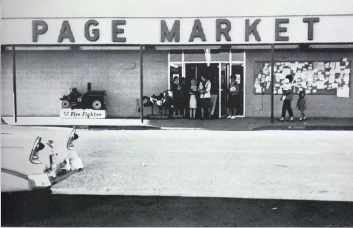
Page Market

Page Market 1961
Page Market, 1961
Source: Unknown

Roueche’s Page Market stood adjacent to the Page Post Office in the plaza on the north side of Elm Street. I believe the post office is still there. In this photo, the post office is just off the picture to the right. These were adjacent businesses in one continuous building. Page Market was the only competition in town at the time to Babbitt’s Thriftway. Since the closing of Page Market (I don’t remember what year that was), several other businesses have occupied this space, but the one I remember most was Yellow Front/Checker Auto. I’m not sure what’s there now.

When I was a little tyke, probably about the time of this photo, I remember being in Page Market during a torrential rainstorm with my mom. We were at one of the checkout counters when the wall between Page Market and the post office moved a little and water started pouring in the Page Market side from the top of the wall. I remember my mom picking me up and putting me on the counter. I don’t remember what happened next, but I’m still alive so I guess it had a happy ending, at least for me. Oh, and several years later I found a $20 bill just outside the other set of doors that were around the corner to the left of this picture. If that was yours, so sorry. But finders-keepers.  I also remember that crowded bulletin board. It was Page’s early version of Craig’s List.

-Mike

Where’s Waldo?

Photo: A. E. Turner, USBR 2/28/1964 Courtesy of the Legate family.
Photo: A. E. Turner, USBR. Dated: 2/28/1964
Courtesy of the Legate family.

This picture is a real prize. There is no caption on the back, so I don’t know what event was going on that prompted this. Before we talk about the faces in it, let me set the location for you.  This is in the intersection of South Navajo and 7th Avenue (Lake Powell Blvd). The Pink Sans is behind the camera and this view is toward the football field. The opening in the chain link fence to the right of the tree was the entrance to the football field. Do you see the stop sign on the right side? That’s South Navajo Drive. We had no traffic signals. Most corners had yield signs and some, like this one, had a stop sign. Do you see the (not-so-grand) grandstands near the center of the picture? The goal posts are also visible, the north one more so. To the left of the grandstands is the old snack bar and further to the left, you can see the scoreboard. It’s that rectangular black thing about 15 feet off the ground. I’ll have more to say about that in a different post.

Behind all of the football field stuff, you can see the old teacher’s apartments. These were along church row. This is also a good shot of LeChee Rock in the distance. Hmmmm, no power plant…

Now for the good stuff. Were you in this picture? Do you see yourself in this shot? If so, and you want to ‘fess up, please do. I need some help here. I looked for myself in it, but I can’t find myself (that sounds like a U2 song!). What was happening here? I suspect it was the beginnings of a parade, but that’s just a guess. Page was big on parades back then. This picture was taken from an elevated platform and the woman taking the other picture is on a different platform. Maybe they were parade floats. I don’t know.

Let’s look at some names. I’ve been able to identify a handful of the people in this. A few were my classmates, but I’m not sure where I was. Here’s what I have so far:

  • My half brother is the one in front between the two guys waving their hands.
  • Don Diamond
  • Larry Patterson
  • Jim Garber
  • Larry Sanderson
  • Theresa Kocjan
  • Marla Kocjan
  • Nancy Mayes (?)
  • Darryl Diamond
  • Larry Sanderson’s sister. I don’t remember her name for sure. Maybe Gini?
  • The woman with the camera may have been Mrs. Patterson.
  • There are several other faces that I recognize, but the names escape me.

If you were in this picture and/or can tell us what was going on that day, please leave a comment below.

-Mike

This is a Dam Site

GCD 1961
Glen Canyon Dam 1961.

This shot was taken from an old Page High School yearbook and is a downstream look at Glen Canyon Dam in 1961. My apologies for the page crease down the middle. Pretend it’s not there.

It looks like the footbridge is still there. If you enlarge this picture and look close, you can see the posts on either side of the canyon and each end of the bridge. You can also see the shadow it’s casting on the canyon floor just upstream of the dirt dam that’s diverting the river water.

The original visitor’s center is to the left of the bridge on US 89. That building was later moved into town and became the LARC Center, located next to the football field at the corner of South Navajo Drive and 7th Avenue (now Lake Powell Blvd).

The town of Page is clearly visible in the upper left of the picture. The golf course and Country Club can be seen near the top right of the picture, on the far end of the canyon. The small body of water on top of the canyon next to the golf course was the old waste water treatment pond. That’s all I’m going to say about that.

I don’t remember what the large building on the left was, next to the highway. I remember it being there, but I don’t remember what it was. If you can add more info about it, please comment below. The “Add a Page to your Trip” road sign that I mentioned in my first post was located on the highway turnoff to Page at the upper left of this picture.

I remember this stage of the dam construction well. It seems like we ended up out there almost every day, watching the construction progress. At night, there was a flashing “Cocktails” sign on the rim of the town that belonged to a bar on Vista Avenue. I was too young to go bar hopping, but I remember that sign well.

-Mike

More Dam Construction

damleft 1962
1962 Dam Construction

My last post showed a look at the right side of Glen Canyon Dam during construction in 1962. In the name of leaving nothing undone, here the other half of the picture showing the left side.

This is a spectacular shot looking upstream at what is mostly under water now. The cement plant is visible on the left behind the bridge just below where the visitor’s center now stands.

Do you see the black line across the bottom of the canyon and up the canyon wall on the right? I don’t know if that’s just something on the picture or if it’s a shadow from the original footbridge. I’m not sure when the footbridge came down. Was it still there in 1962? Anybody? If you know, feel free to chime in.

You can see the water that’s being diverted around the dam at the bottom left of the picture. I think it was being diverted on the other side too.

Dam Construction

Early 60s Dam Construction
1962 Dam Construction

This is a great shot of Glen Canyon Dam under construction from 1962. I don’t remember where I got this picture but it’s one of my favorites because this is how I remember the dam. I spent a lot of time on or near the bridge during this time, watching the dam go up. I must have rode my bike out there a lot with friends just to hang out and watch the construction. It never got old.

From the bridge, the trucks and workers below looked like toys. I remember that elevator on the wall of the canyon. I would watch it carry workers up and down for what seemed like hours. It probably was hours. That was one positive about growing up there. My feet would hit the floor in the morning and I was gone all day.

To the right of this picture, just downstream of the bridge, was the original visitor’s center and lookout. The road down to the old lookout is still there, as is the lookout and parking lot, if anyone’s feeling adventurous.

-Mike

Pink Sans Drive-In

Pink Sands Drive-in, 1961
Pink Sans Drive-in, 1961

I wish this picture was bigger. When I try to enlarge it, it gets blurry. This is the Pink Sans Drive-in circa 1961. It was (and still is) located on 7th Avenue (now Lake Powell BLVD) across from the park. More precisely, it was located across the street from the pool at the park. Yes, there used to be a good sized town pool at the corner of South Navajo Drive and 7th Avenue. I spent many summer days there.

This is the way I remember the Pink Sans looking. It was all outside, covered seating with picnic style tables. Just to the right of this picture was the Chevron gas station and on the other side (in the direction the camera is pointing) was the old Sportsman’s Headquarters. It eventually became a laundromat and after that, who knows. I don’t know what’s there today.

The Pink Sans was like Al’s Diner on Happy Days. It was the place to hang out, so we did. I remember watching occasional high school drag races down 7th Avenue. The Pink Sans was the starting line for those races and it seems like First National Bank, on the corner of Elm and 7th Avenue, was the finish line. There were no traffic signals back then, and evidently, not much traffic either! I’m not sure where the police (they were called Rangers back then) were, but I don’t remember ever seeing any when someone decided to race.

When I hit high school, we usually walked to the Pink Sans to grab a deep fried burrito from Sue, who always seemed to be working there at lunch, followed by some kind of Hostess treat for 13 cents at the Sportsman’s Headquarters next door. Ah the good ‘ole days!

-Mike

New School Buildings

phs-date-street-1961-62
Page Schools 1960-61
Source: Unknown

This aerial shot from 1960 or 61 shows the newly completed school buildings along South Navajo Drive at the intersections of Date Street and 5th Avenue. You can see a few church buildings springing up on church row at the top of the picture. Originally, that was called 7th Avenue but was renamed to Lake Powell Blvd a number of years ago. The teacher’s apartments are the long buildings on this side of 7th avenue. They’re no longer there. I guess someone thought it would be a good idea to round up all of the teachers and keep them in one spot for easy handling. Probably not a bad idea. Ha!

Ok, back to the picture. The oval shaped area on the left side of the picture is the football field and track. The bleachers are the small strip next to the field. I have a cool ground shot of the field and scoreboard that I’ll be posting soon. The area behind the bleachers was little more than a big sand pit used for football practice. I remember running wind sprints in full pads in that sand that seemed to be 4 feet deep. I get winded just thinking about it now.

I don’t know how these buildings are referred to now, but they were originally labeled by letter. The larger building on the left was A Building. The small one next to it was B Building (I know, pretty creative!). Both of these building housed the high school. The large building in the middle was the Gym (C Building) and the long one near the bottom was D Building. D Building was home to the junior high-ers and I think down to 3rd or 4th grade originally. I was in D Building when President Kennedy was shot. I was in 3rd grade, so it must have gone that low. What’s not shown in this picture is the old X and Y buildings that housed the 1st and 2nd grades for a few years. Those were to the right of this picture along 7th Avenue across from the Catholic Church. X and Y Buildings were long, temporary, wooden buildings where I started 1st grade. At the bottom of D Building, you’ll see a small fenced-in concrete slab that was called the playpen. We spent recesses out there playing anything we could play with a ball.

If I remember right, the square area just above the gym was blacktop. There must have been basketball posts there, but my memory of it is pretty sketchy. Cedar Street is just off the picture on the bottom left corner. Those two houses there are facing Cedar Street. We lived in the 2nd or 3rd house from Date Street on the north side of Cedar Street for a time. I remember listening to Beatles 45 records in the front yard.

It looks like there is still some construction going on with the Bureau homes in this picture, at least in the back yards and easement. The sand was always horrible during windy days and getting it under control seemed to be a constant battle. Check out the row of small trees there were planted in the front yards along South Navajo.

Does anyone else remember the school crossing guards that worked that corner of Date and South Navajo? They were older school kids who got to wear uniforms and carry big flags. When we got to the corner and needed to cross, they would lower those big flags to a 45 degree angle and walk out ahead of us to stop traffic (one on each side of Navajo Drive). I remember thinking how cool that was I wanted so bad to become a crossing guard. I wish I had a picture of them to show you.

For comparison, here’s an aerial view of the same spot today:

-Mike

2013 aerial

Green Thumb Nursery

60-green-thumb-nursery
Green Thumb Nursery, circa 1961
Source: Unknown

Does this building look familiar to my Page friends? It’s the old Green Thumb Nursery and the building that housed it was (is) located at 810 N. Navajo Drive. I don’t remember who owned it or who ran it, but I do remember peering in those windows a lot. If you can help add some background to this, please jump into the conversation and let me know.

This building eventually housed a fix-it/small appliance shop that always reminded me of Emmit’s Fix-it shop from the old Andy Griffith show. I don’t remember the name of that business but it may have been run by the Dolands. That sticks in my mind for some reason. Maybe Mrs. Doland just worked there, but I seem to remember her in there a lot. They also owned/ran the movie theater and Doland’s Curios Shop, which was located a couple of doors down from the theater. But I digress…

It seems like it sat closed for quite a while, but it eventually became Bella Napoli Italian Restaurant. No wonder I always liked their salads! Today, I think it’s called Bonkers. By the way, is that a Buick sticking its nose in the left side of this picture? It might be. Our family had one with that body style. If that’s a Buick, I’m not saying it was ours, but it could have been. Just sayin’. I’d sure take that pickup in a heartbeat though. And that VW bus would look real good in my garage!

Speaking of VW busses, here’s a shot of yours truly in 1974 filling up my bus at Specht’s gas station and car wash. This was located next door the Green Thumb Nursery building, across the street from what would one day be Stromboli’s. I don’t think Specht’s is there anymore, but if I’m wrong, let me know.

-Mike

Yours Truly with my VW bus in 1974. Photo: Susan Adams