Glen Canyon Dam lower footbridge under construction. 1958? Source unknown.
Who remembers this? If you take a look at my last post, you’ll see a portion of this footbridge near the bottom of that photo. It spanned the lower part of the canyon at the approximate location of the present-day powerhouse. This picture is taken from the Page side at the bottom of the canyon. The powerhouse tunnel exit is behind the photographer and to his left. This is a good shot of the canyon wall at the spot where the dam now sits.
The footbridge is still under construction on this photo. Either that, or you had to get a running start to make it across. This picture is undated and I don’t remember now where I got it. But due to its quality and the fact that it’s black and white, I’m guessing it’s a USBR photo and that it was taken around 1958. But that’s just my best guess. If anyone can give me more info on the history of this bridge, please do.
Photo: A. E. Turner, USBR 9/10/1958 Source: The LeGate Family
The building of Glen Canyon Dam and Bridge wasn’t accomplished without great personal loss by some. I’m posting two photos this time because they are closely tied to one another. The handwritten caption on the back reads,
“Lower end of diversion tunnel and adit for powerhouse tunnel road. Right above the adit is where the man got killed Aug 11th. Rock ledge 200 feet above adit broke off. Small footbridge across river is at lower left.”
You can clearly see the lower opening to the powerhouse tunnel mentioned in the picture. It’s located at the base of the dam, next to the powerhouse. The lower footbridge mentioned in the caption and visible in the photo was at the approximate location of the powerhouse. My next post will be a better look at that lower footbridge. The powerhouse tunnel runs along the inside of the canyon wall from behind the old Country Club/golf course on top, to this point below. It’s still in use. The adits mentioned in the caption are the smaller horizontal tunnels that intersect the main tunnel at 90 degrees at regular intervals, primarily for ventilation. If you scroll back up to the picture, you’ll see the adit that is mentioned in the caption.
The photo was taken or cataloged one day short of a month following a fatality at this location that occurred on 8/11/1958. The photo caption mentions that a rock ledge broke off above the adit and killed a man. According to the memorial plaque below, the individual’s name was Austin Merritt. He joins 17 others who lost their lives in the Glen Canyon Dam project. All of them are listed here:
This memorial lists the names of the 18 individuals who lost their lives during the construction of Glen Canyon Dam and bridge. Source: Wmpearl (Own work) [CC0], via Wikimedia Commons
The above memorial plaque was created by WMPearl in 2011 and is posted on Wikimedia Commons. I don’t know where it physically resides. Click [HERE] to view the source website at Wikimedia.
In the early 1970’s, one of my friends told me that her father was killed during the building of the dam. His name is listed at the top of the middle column, Raymond D White.
UPDATE 5/24/17: Here’s a list of memorials of the names on the plaque compiled by Donna Bloxton Petersen. Thank you Donna for all the time and work you put into this!
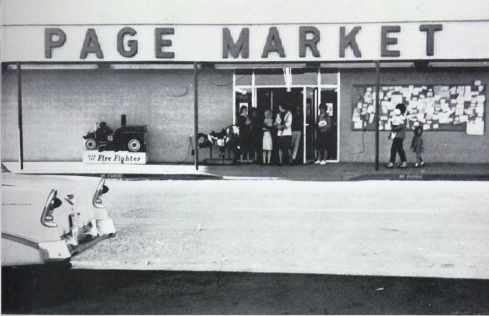
Roueche’s Page Market stood adjacent to the Page Post Office in the plaza on the north side of Elm Street. I believe the post office is still there. In this photo, the post office is just off the picture to the right. These were adjacent businesses in one continuous building. Page Market was the only competition in town at the time to Babbitt’s Thriftway. Since the closing of Page Market (I don’t remember what year that was), several other businesses have occupied this space, but the one I remember most was Yellow Front/Checker Auto. I’m not sure what’s there now.
When I was a little tyke, probably about the time of this photo, I remember being in Page Market during a torrential rainstorm with my mom. We were at one of the checkout counters when the wall between Page Market and the post office moved a little and water started pouring in the Page Market side from the top of the wall. I remember my mom picking me up and putting me on the counter. I don’t remember what happened next, but I’m still alive so I guess it had a happy ending, at least for me. Oh, and several years later I found a $20 bill just outside the other set of doors that were around the corner to the left of this picture. If that was yours, so sorry. But finders-keepers. I also remember that crowded bulletin board. It was Page’s early version of Craig’s List.
Photo: J. L. Digby, USBR 10/6/1958 Courtesy of the LeGate family.
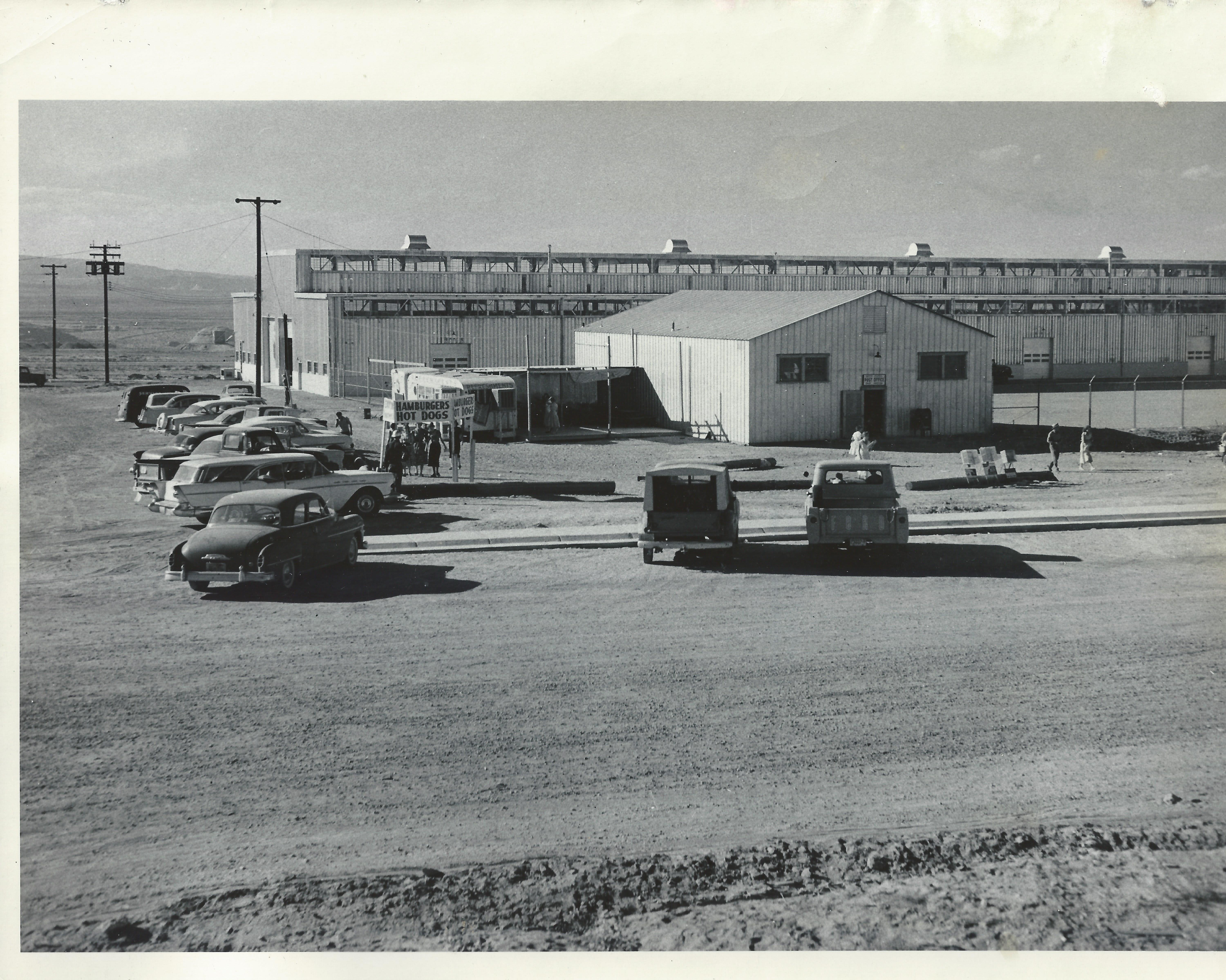
This picture, dated 1/6/1958 is another view of the post office with the USBR warehouse behind it. The warehouse is still there, but this post office is long gone. The Windy Mesa was eventually built just to the right of where this post office sat, on North Navajo Drive. This picture was taken from the approximate location of present day Stromboli’s. The fire station and old USBR ranger station were to the left of this picture. I did a separate post about this post office building [HERE]. Now I know where it was located.
I’m not sure if the hamburger and hotdog stand was a regular event, or if there was something special going on this day.
Photo: A. E. Turner, USBR. Dated: 2/28/1964 Courtesy of the Legate family.
This picture is a real prize. There is no caption on the back, so I don’t know what event was going on that prompted this. Before we talk about the faces in it, let me set the location for you. This is in the intersection of South Navajo and 7th Avenue (Lake Powell Blvd). The Pink Sans is behind the camera and this view is toward the football field. The opening in the chain link fence to the right of the tree was the entrance to the football field. Do you see the stop sign on the right side? That’s South Navajo Drive. We had no traffic signals. Most corners had yield signs and some, like this one, had a stop sign. Do you see the (not-so-grand) grandstands near the center of the picture? The goal posts are also visible, the north one more so. To the left of the grandstands is the old snack bar and further to the left, you can see the scoreboard. It’s that rectangular black thing about 15 feet off the ground. I’ll have more to say about that in a different post.
Behind all of the football field stuff, you can see the old teacher’s apartments. These were along church row. This is also a good shot of LeChee Rock in the distance. Hmmmm, no power plant…
Now for the good stuff. Were you in this picture? Do you see yourself in this shot? If so, and you want to ‘fess up, please do. I need some help here. I looked for myself in it, but I can’t find myself (that sounds like a U2 song!). What was happening here? I suspect it was the beginnings of a parade, but that’s just a guess. Page was big on parades back then. This picture was taken from an elevated platform and the woman taking the other picture is on a different platform. Maybe they were parade floats. I don’t know.
Let’s look at some names. I’ve been able to identify a handful of the people in this. A few were my classmates, but I’m not sure where I was. Here’s what I have so far:
My half brother is the one in front between the two guys waving their hands.
Don Diamond
Larry Patterson
Jim Garber
Larry Sanderson
Theresa Kocjan
Marla Kocjan
Nancy Mayes (?)
Darryl Diamond
Larry Sanderson’s sister. I don’t remember her name for sure. Maybe Gini?
The woman with the camera may have been Mrs. Patterson.
There are several other faces that I recognize, but the names escape me.
If you were in this picture and/or can tell us what was going on that day, please leave a comment below.
Photo: A. E. Turner, USBR 8/6/1958 Courtesy of the LeGate family.
The back caption on this photo dated 8/6/1958 reads, “Men working on bridge. View point for visitors in background.” I’ve mentioned the old visitor’s center and the lookout point in a few of my previous posts. You can see the parking lot in the background on the Page side of the canyon in this picture. Access to the parking lot and lookout was from US 89, just above this photo. The camera angle is pointing almost directly to Manson Mesa and Page.
You can see the walkway coming off the right side of the parking lot. It looped back to the covered lookout point below the parking lot. You can see some people there (just in front of the guy in white) taking advantage of the good view. Yours truly took advantage of that view countless times too. The guy at the bottom of the picture looks like he’s carrying something pretty heavy. The guy in front of him looks to be texting. 🙂
This picture looks to have been taken just past the center of the bridge on the Page side of the bridge as you can see the arch beginning its downward slope on the left toward the canyon wall. You can get good look at the net below too.
Manson Mesa Pool Under Construction 10/6/1958 Photo: J. L. Digby, USBR Courtesy of the LeGate Family
Who remembers the Manson Mesa Pool? I sure do. I spent many hours in that pool on those long, lazy summer days. I even spent a lot of time in it after it was closed down and drained. But that’s another story for another time. This photo is dated 10/6/1958 and the back caption simply reads, “Swimming pool.”
The Manson Mesa Pool was located on South Navajo Drive, adjacent to the park, on the corner of Seventh Avenue (now Lake Powell Blvd) and South Navajo. This photo was taken from near the curb of South Navajo, looking north-ish, parallel to Seventh Avenue. The Pink Sans Drive-in is (or soon will be) to the right of this picture, across Seventh Avenue. The park will be to the left of the picture. The brick building in the distance, just to the left, is the Page Hospital. It appears to be under construction in this photo. The white building to the left of the hospital is the USBR HQ that I blogged about in a previous post. I don’t know who the worker is in this picture.
There is no evidence today that this pool ever existed, much like the old drive-in theatre. Progress?
Photo: A. E. Turner, USBR 7/21/1958 Courtesy of the LeGate family.
This photo had some water damage, so I’m glad I was able to scan it. It’s dated 7/21/1958 and the handwritten description on the back reads, “Tower for cableway under construction.” This was one of three towers on this side of the canyon that rode on railways. This one may have been in a fixed position. I don’t remember for sure. There were three more on the Page side of the canyon. Cables spanned the canyon from these towers and were used to dump concrete, move material, and transport workers into and out of the canyon.
This one is shown on what is today, the upper parking lot of the Visitor’s Center. The Visitor Center itself would eventually be built to the left of this picture.
Photo: J. L. Digby, USBR 10/6/1958 Courtesy of the Legate Family
I appreciate the clean look of this photo, dated October 6, 1958. The handwritten back caption reads, “Municiple buildings where big cheeses from Bureau work.” If you live in, or have lived in Page for any length of time, you probably recognized this building right away. It sits on the corner of North Navajo Drive and Vista Avenue. If you type Page Arizona into Google Earth and go to that intersection, you’ll get a good look at how it appears today.
In addition to the USBR administrative offices, this building has also been the Page Municiple building and courthouse and the National Park Service headquarters. I seem to remember the library being in there too, but I may be having a senior moment. Can somebody help out a brother here? If you remember, let me know.
The fact that there is no other development anywhere in this picture makes it that much better. I like that North Navajo Drive is still dirt. Vista Avenue is to the right in this picture and today, the Page hospital sits across the street (Vista Ave) to the right of the photo. Did I mention that I like the pickup truck on the far right side?