It’s a Dam Site

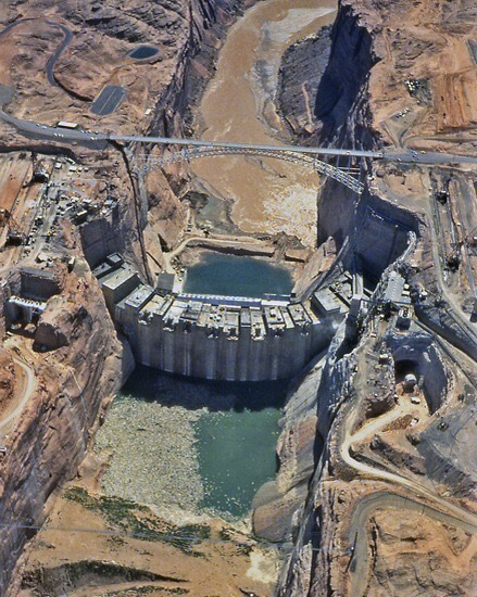
Glen Canyon Dam Construction, 1962 or 63. Source unknown.

There’s a lot of good detail in this photo.It’s a good look at both spillways and the temporary coffer dam at the bottom of the picture. The concrete batch plant is visible on the canyon edge to the right. Water is visible exiting the right diversion tunnel, but not the left. The left diversion tunnel inlet was about 33 feet higher than the right tunnel inlet and was intended to be used only during high river flows. The parking lot for the lookout point is visible on the left, just above the bridge. The rectangular building along the highway on the left side of the bridge was the original visitor’s center. It was later moved into town and became the LARC center. I don’t remember what that acronym means. The rail-mounted cranes are visible on either side of the canyon. There were two 25-ton cranes and one 50-ton crane on each side. In addition to transporting buckets of concrete to the dam, these cranes were used to transport people and equipment in and out of the dam site. Near the bottom right corner of the picture, you can see the tower structure holding the footbridge, and the footbridge is visible too. The dark area by that tower, that curves around the sandstone knoll, was the road/parking lot for the footbridge. You can still see the remnants of that road on Google Earth. Go take a look.


Enjoy!

Mike
Videos: Glen Canyon Dam Construction

These are five videos by Gary Ladd on the construction of Glen Canyon Dam. There are some really good shots and info in these. When you watch them on YouTube, one video goes right into the next. I’m not sure if that will happen here too, so I’m putting all five parts in this single post. These are also on my Videos page in the link in the sidebar.

Part One:

Part Two:

Part Three:  Continue reading

A Bridge Under Construction

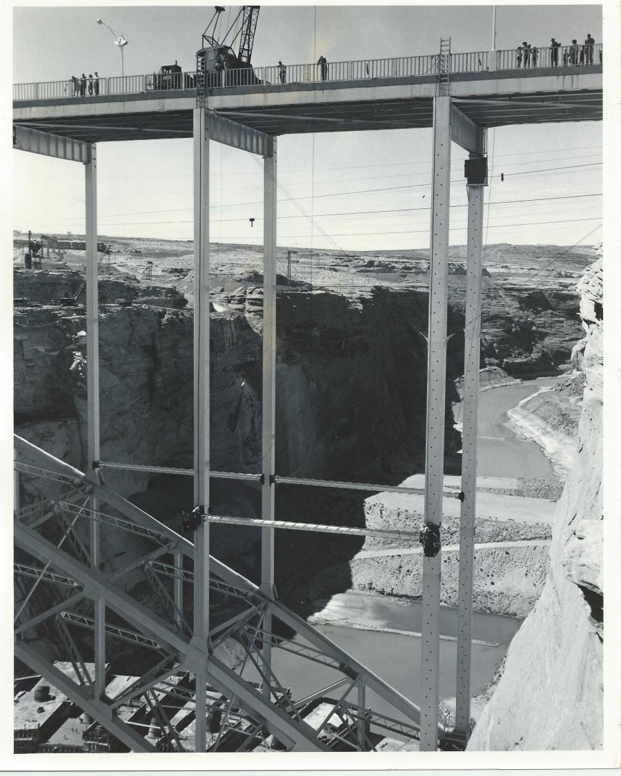
Source: The LeGate Family, 1961

This is a great shot of the bridge. I was looking closely at the detail in it (the resolution on some of these early black & white photos is amazing) and noticed quite a few things. Click on the picture to open it up and then zoom in. Here’s what I noticed:

First, it looks like it was taken from the old visitor lookout on the Page side of the canyon. Do you remember that spot? It’s still there but blocked off. It provided a great view of the dam and bridge from just downstream of it. There was a parking lot and a short trail down to the lookout. You can still see it on Google Earth. Back to the picture. This is looking upstream. Notice that on top of the bridge, construction is going on while visitors are allowed to be there. I don’t think anyone would get away with that today. You can see the footbridge in the background. This also provides a good shot of the dirt coffer dam that was built to divert water (via the diversion tunnels) around the dam site during that early construction. Notice too, the first few levels of the dam that have been poured. The penstocks are visible, angling out of the top of each level. Look how small the people are standing on the dam. Notice too, the wooden walkways and stairs between each section. Those were constantly being moved as the dam went up. I remember standing on the bridge so many times, watching these same things going on below.

Did you notice the ladders at the top of the bridge? Do you see the cables tied to the handrails by the ladders? Follow them down to the horizontal cross brace and you’ll see two workers (one on each end of the brace) working to secure the cross brace to the main structure. You can see the cable from the crane on top between the two workers at the top. It looks like the crane is holding that cross brace in place while it’s being attached. You’ll notice the cross braces on the other side of the bridge are already in place, but the one to the left of the one they’re installing is yet to be added.

Enjoy!

-Mike

Operation Glen Canyon

This is a pretty cool  28 minute video documentary on the first four years of construction of Glen Canyon Bridge and Dam. Thank you Donna for posting this link on our Facebook page!

Enjoy!

A Day in the Life: 10-30-1958, Part Two

This is part two of my previous post featuring newspaper clippings from the October 30, 1958 edition of the Page Signal, the forerunner to the Lake Powell Chronicle. Here’s some more happenings that were printed that week:

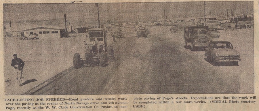
Photo Courtesy of the LeGate Family. Page Signal: 10-30-1958.

If my compass is correct, this is a look east along North Navajo and Seventh Avenue (now Lake Powell BLVD) is about where the photographer is located. You can see some of the early businesses  and a little of the MCS trailer court in the top right of the photo. I talked about them in some previous posts. You can see a clearer picture of those first buildings —>HERE<—

Doctor Kazan was the happy recipient of Page’s 300th phone! You can see an Continue reading

The Left Key-Way

Photo: Probably USBR. Courtesy of Terry Edwards. Undated

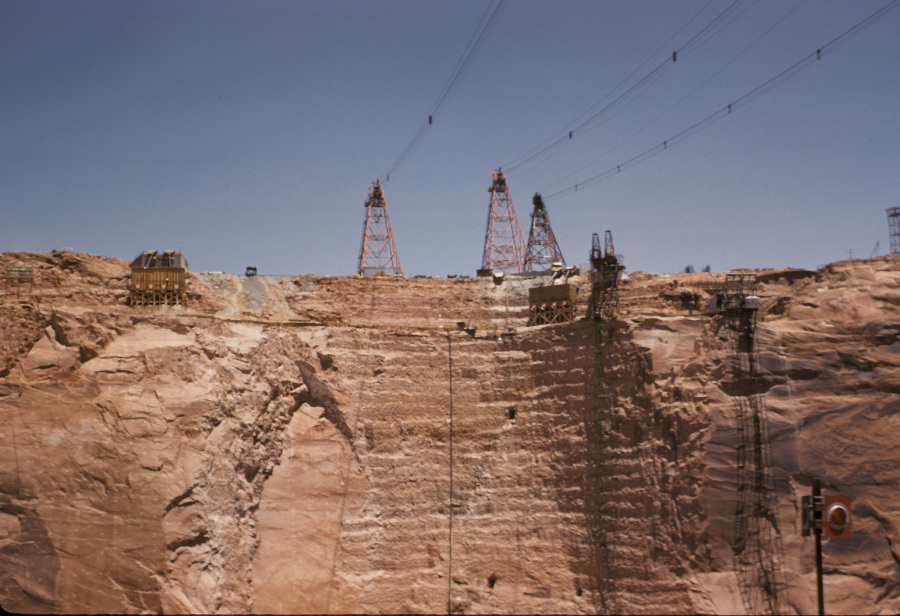
Here’s a great look at the left (Page side) key-way for Glen Canyon Dam. The key-ways were the vertical cut outs in the canyon walls where the dam was anchored into the rock. You can see two rectangle tunnels in the key-way and a third one to the right. I’m not sure what that third one was for, but there were a total of four of the other tunnels spaced along both key-ways. As the dam was built, these were connected to walkways inside the dam that ran the full length of the dam from edge to edge. There was instrumentation placed in those tunnels to measure stability and movement, and probably a lot of other things I’m not aware of. But having been inside at least one of them once the dam was finished, I remember how cold, wet, and eerie it was. I can also still remember the smell – like wet concrete. But I digress.

The towers above were the mobile cranes that rode along tracks and could move back and forth to move materials, people, and dump concrete buckets during the construction of the dam. There were three more on the opposite side of the canyon, behind the photographer. On the right side of the key-way is an elevator that ran on vertical rails up and down the canyon wall. I remember watching that thing from the bridge as it shuffled people in and out of the canyon. It seems like there was another smaller one to the right of that one, but it’s all a blur. I’m not sure what the wooden structures at the top of the key-way were.

Enjoy,

-Mike

Friday Freebie: How To Navigate a Foot Bridge

From my archives. Undated and source unknown.

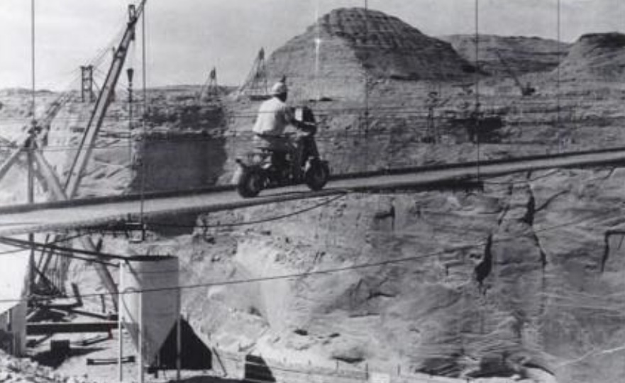
Here’s a little something to take into your weekend. Remember, always wear a helmet. Especially if you’re crossing a footbridge 700+ feet above a canyon floor, with minimal or no side rails.

-Mike

Below The Coffer Dam

Photo: USBR. July, 1959. Courtesy of Terry Edwards.

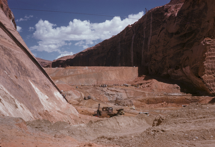
I love the detail in these old USBR photos. If you zoom in on them, you can see some pretty cool stuff. This one is no exception. It gives us a good downstream look at the temporary coffer dam. You are looking upstream toward what would eventually become Lake Powell. The coffer dam was built to divert the Colorado River water into the two spillway tunnels that routed the water through the canyon walls to the downstream side of the dam site. The right side tunnel (the Visitor Center side) was the primary tunnel and it handled most of the diversion water.

The excavation going on in this picture is prep work for laying the base of the dam. I remember reading or hearing somewhere that the base concrete for Glen Canyon Dam was poured 135 feet below bedrock. This picture captures that excavation. Some of the dirt and rock that was Continue reading

Video: Glen Canyon Dam Construction

This video has some excellent shots of the construction of Glen Canyon Dam. It’s part 2 of a 5-part series by Gary Ladd in what looks like a lecture at NAU. I put all 5 parts on a new video page. Click the Videos tab above to get there, or just click HERE.

Enjoy… Mike