Hey all, we’re on a road trip for the month of July but I wanted to stop long enough to get this amazing picture posted. This is my first post via email, so I hope it looks ok when posted. If not, I’ll tweak it later. Gene LeGate sent this pic to me a few days ago (thanks Gene!). I don’t know who took it, what building it was (it looks like one of the Butler Buildings used for the first school), where it was being moved to, or why. But here’s what I do know: it’s being moved away from town and it was a rainy day.
If you have some info about this picture and what was going on, please leave a comment. It seems like something like this would have drawn some attention.
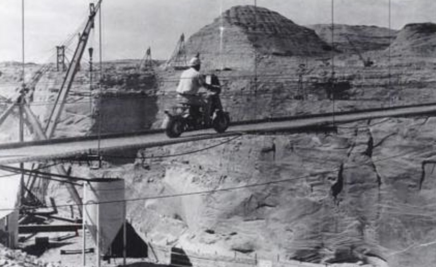
Here’s a little something to take into your weekend. Remember, always wear a helmet. Especially if you’re crossing a footbridge 700+ feet above a canyon floor, with minimal or no side rails.
Photo: USBR. July, 1959. Courtesy of Terry Edwards.
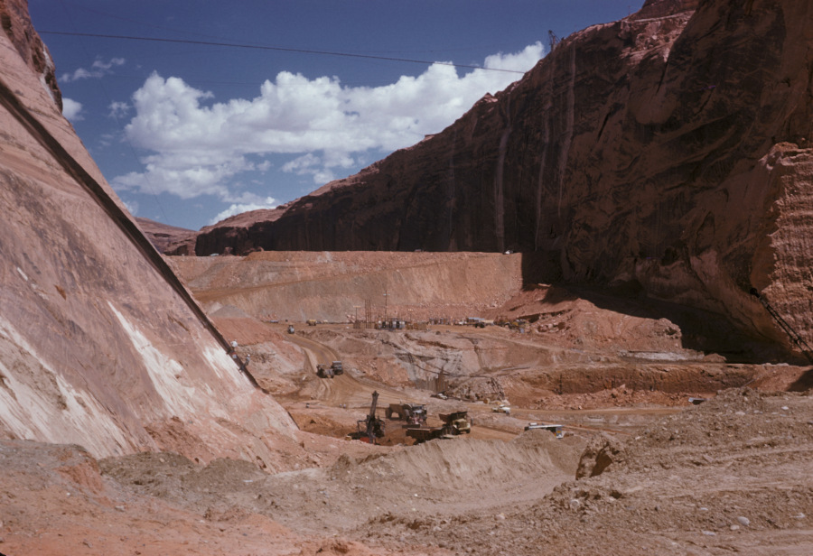
I love the detail in these old USBR photos. If you zoom in on them, you can see some pretty cool stuff. This one is no exception. It gives us a good downstream look at the temporary coffer dam. You are looking upstream toward what would eventually become Lake Powell. The coffer dam was built to divert the Colorado River water into the two spillway tunnels that routed the water through the canyon walls to the downstream side of the dam site. The right side tunnel (the Visitor Center side) was the primary tunnel and it handled most of the diversion water.
The excavation going on in this picture is prep work for laying the base of the dam. I remember reading or hearing somewhere that the base concrete for Glen Canyon Dam was poured 135 feet below bedrock. This picture captures that excavation. Some of the dirt and rock that was Continue reading →
This video has some excellent shots of the construction of Glen Canyon Dam. It’s part 2 of a 5-part series by Gary Ladd in what looks like a lecture at NAU. I put all 5 parts on a new video page. Click the Videos tab above to get there, or just click HERE.
Photo: A. E. Turner, USBR Undated Source: The LeGate Family
This photo is undated, but I think it must be 1957ish. The handwritten caption on the back reads,
“In bottom of canyon upstream from bridge. Concrete form for diversion tunnel shown here. To the bottom left is tunnel (mile plus long) which will connect the power house to top of canyon wall and to Page.”
There are a couple of things that need pointed out on this photo. The writing I cited above mentions a diversion tunnel and a tunnel that goes to the top of the canyon wall. Those are two different things. The opening mentioned on the left of the picture is the bottom of the tunnel that runs from there to the top of the canyon and comes out behind the old Country Club an golf course. That tunnel is still in use. The lower opening to the tunnel that you see in this picture is now on the downstream side of the dam and comes out near the power house. The next time you’re there, look down and you’ll see it. It’s interesting that the back caption says this tunnel WILL connect the top to the bottom, as it was still under construction at the time of this photo.
The concrete form mentioned in the picture is the round object on the right. There were two diversion tunnels that re-directed the Colorado River water around the dam site during construction. In future posts, I’ll be sharing some pictures with you of construction inside those diversion tunnels, as well as the upper spillways which connected to the diversion tunnels.
Notice the roadway in the center of the bridge and the road protruding out from the canyon on the right side. The present-day visitor’s center is located on the right side of this picture by the road. Also notice the netting that hung off the bottom of the bridge to catch falling workers and material. The cables that spanned the canyon are clearly visible and it looks like there is another roadway support being set at the time of this photo. This view is long gone!
This shot was taken from an old Page High School yearbook and is a downstream look at Glen Canyon Dam in 1961. My apologies for the page crease down the middle. Pretend it’s not there.
It looks like the footbridge is still there. If you enlarge this picture and look close, you can see the posts on either side of the canyon and each end of the bridge. You can also see the shadow it’s casting on the canyon floor just upstream of the dirt dam that’s diverting the river water.
The original visitor’s center is to the left of the bridge on US 89. That building was later moved into town and became the LARC Center, located next to the football field at the corner of South Navajo Drive and 7th Avenue (now Lake Powell Blvd).
The town of Page is clearly visible in the upper left of the picture. The golf course and Country Club can be seen near the top right of the picture, on the far end of the canyon. The small body of water on top of the canyon next to the golf course was the old waste water treatment pond. That’s all I’m going to say about that.
I don’t remember what the large building on the left was, next to the highway. I remember it being there, but I don’t remember what it was. If you can add more info about it, please comment below. The “Add a Page to your Trip” road sign that I mentioned in my first post was located on the highway turnoff to Page at the upper left of this picture.
I remember this stage of the dam construction well. It seems like we ended up out there almost every day, watching the construction progress. At night, there was a flashing “Cocktails” sign on the rim of the town that belonged to a bar on Vista Avenue. I was too young to go bar hopping, but I remember that sign well.
My last post showed a look at the right side of Glen Canyon Dam during construction in 1962. In the name of leaving nothing undone, here the other half of the picture showing the left side.
This is a spectacular shot looking upstream at what is mostly under water now. The cement plant is visible on the left behind the bridge just below where the visitor’s center now stands.
Do you see the black line across the bottom of the canyon and up the canyon wall on the right? I don’t know if that’s just something on the picture or if it’s a shadow from the original footbridge. I’m not sure when the footbridge came down. Was it still there in 1962? Anybody? If you know, feel free to chime in.
You can see the water that’s being diverted around the dam at the bottom left of the picture. I think it was being diverted on the other side too.
This is a great shot of Glen Canyon Dam under construction from 1962. I don’t remember where I got this picture but it’s one of my favorites because this is how I remember the dam. I spent a lot of time on or near the bridge during this time, watching the dam go up. I must have rode my bike out there a lot with friends just to hang out and watch the construction. It never got old.
From the bridge, the trucks and workers below looked like toys. I remember that elevator on the wall of the canyon. I would watch it carry workers up and down for what seemed like hours. It probably was hours. That was one positive about growing up there. My feet would hit the floor in the morning and I was gone all day.
To the right of this picture, just downstream of the bridge, was the original visitor’s center and lookout. The road down to the old lookout is still there, as is the lookout and parking lot, if anyone’s feeling adventurous.
Check this out! Early construction shot of the dam site. The beehive is clearly visible near the center of the picture. The dark mesa on the left side of the picture near the top is the Page town site. There’s nothing there yet to speak of, but that’s either smoke or dust in the top left corner. It looks like there’s some building going on, but I’m not sure what it was. If you have any info you can add to this pic, please leave me a comment below.
Here’s something really cool. If you look close at the canyon in this picture, just this side of where the dam is to be built, you can see a tiny line across the canyon. I’m pretty sure that’s the footbridge I mentioned in a previous post HERE.
I received an email this week from someone who’s husband had started working there in February 1957, almost a year before this photo was taken in November, 1957. In December 1957, their whole family moved here. When we moved there in 59-60, their son and I quickly became best friends. I’m thankful we’re back in touch after all these years.