Not Norman Rockwell

Source: Terry Edwards Date and Photographer Unknown
Source: Terry Edwards
Date and Photographer Unknown

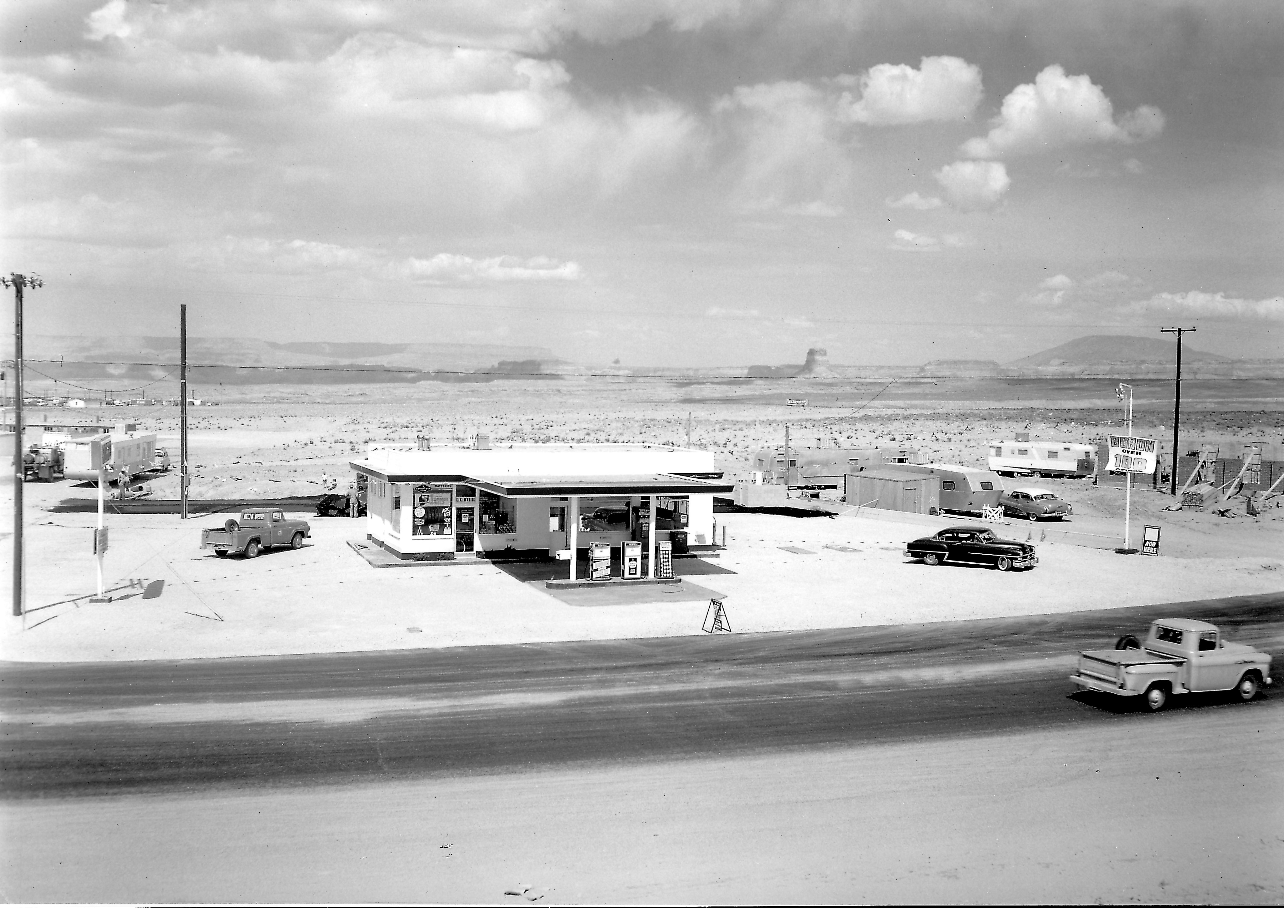
This first picture looks like something out of a Normal Rockwell painting. My first thought was that it was the original Exxon (Enco) gas station on the corner of 7th Avenue and Elm, but the wall under construction on the right side of the photo would have to be the Empire House, and that’s not the Empire House. Plus, other pictures of the old Exxon station show a completely different layout with two garage bays on the left side of the building. That’s how I remember it.

After digging a little further, I realized this is the old Richfield station that was on the corner of South Navajo and 7th Avenue (Lake Powell BLVD). You can see 7th Avenue starting to curve toward church row. The building under construction on the right is the First Baptist Church. The last time I was in Page, this gas station had been turned into a fast food restaurant. The quality of this photo is amazing. So are the two pickup trucks! The MCS apartments are visible on the left behind the small trailers. It looks like they’re under construction. The white building further back is probably the American Legion building and beyond that, the original trailer court. This is a good shot of Tower Butte and Navajo Mountain in the background. I’m not sure what that billboard says in the background. Even zoomed in, I can’t read it.

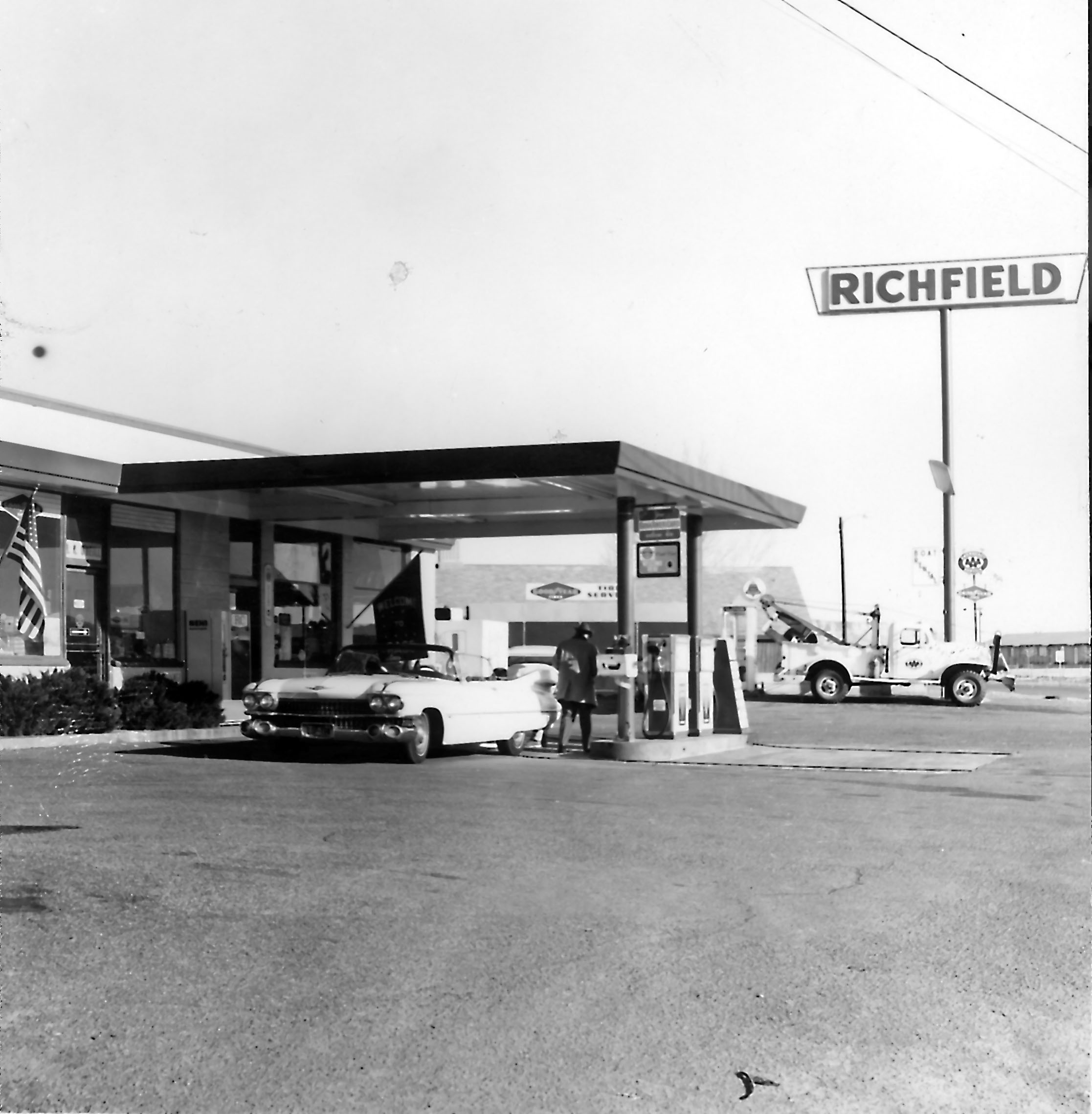
The bottom picture is of the same building some time later. I wonder if the Cadillac was pink. Neither picture is dated and I don’t know who the photographer was.
Source: Terry Edwards Date and Photographer Unknown
Source: Terry Edwards
Date and Photographer Unknown

-Mike

Route 66: Season One, Episode Nine

Route 66
A scene from season 1, episode 9 of Route 66 filmed in Page.
Photographer and date unknown.
Source: Terry Edwards

There were a lot of movies and a handful of TV episodes filmed in the Page area in those early years. The ones that stand out to me while growing up there were The Greatest Story Ever Told, Planet of the Apes, Easy Rider, and later, The Outlaw Jose Wales. But who could forget the epic TV series, Route 66, starring Martin Milner of Adam-12 fame and…. that other guy. What was his name? Oh yea, George Maharis. In the series, they were Tod (with one d) and Buz (with one z). They drove the old Route 66 in that cool Stingray and did things.

Season 1, episode 9 was filmed in Page. The first picture below captured the filming of one of the scenes at or near the airport. The cool Stingray is sitting there, waiting for action. This episode aired on November 2, 1960 and was entitled, Layout at Glen Canyon. If this scene was shot at the airport, I lived a stone’s throw from where it was filmed. Check it out…

I grabbed the screen shot below from the IMDB web site when I searched for Route 66. It filled in some of the gaps for me. Unfortunately, I can’t find that episode anywhere. Netfix only has the first two episodes of season one. I sure would like to watch it. If any of you come across it, please let me know.

I know I said I wasn’t going to blog anything here until after December, but this was too good to wait. Enjoy!

-Mike

December Break

Photo: A. E. Turner, USBR
12/16/1961
Source: The LeGate Family

Hey all, I’m taking a break from blogging for the month of December and I’ll pick back up again in January. I want to leave you with a Christmas picture of early Page. Check it out…

There isn’t anything written on the back of this picture except the name of the photographer and the date. I don’t know who that was dressed up as Santa. At first, I thought this was in the school gymnasium, which would have been new that year. But the more I look at it, I think it was somewhere else. That door in the background has a big window in it and the doors to the gym weren’t like that, at least not that I remember. I also thought at first that those were bleachers along the back wall, but I think it’s only a bench of some sort. Does anyone know what building this was in? There are two faces that I recognize, but I don’t have names to go with them.

How about you? Do you see any familiar faces in this shot? If so, let me know.

Enjoy your holidays and I will “see” you next year!

-Mike

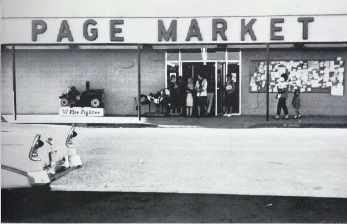
Page Market

Page Market 1961
Page Market, 1961
Source: Unknown

Roueche’s Page Market stood adjacent to the Page Post Office in the plaza on the north side of Elm Street. I believe the post office is still there. In this photo, the post office is just off the picture to the right. These were adjacent businesses in one continuous building. Page Market was the only competition in town at the time to Babbitt’s Thriftway. Since the closing of Page Market (I don’t remember what year that was), several other businesses have occupied this space, but the one I remember most was Yellow Front/Checker Auto. I’m not sure what’s there now.

When I was a little tyke, probably about the time of this photo, I remember being in Page Market during a torrential rainstorm with my mom. We were at one of the checkout counters when the wall between Page Market and the post office moved a little and water started pouring in the Page Market side from the top of the wall. I remember my mom picking me up and putting me on the counter. I don’t remember what happened next, but I’m still alive so I guess it had a happy ending, at least for me. Oh, and several years later I found a $20 bill just outside the other set of doors that were around the corner to the left of this picture. If that was yours, so sorry. But finders-keepers.  I also remember that crowded bulletin board. It was Page’s early version of Craig’s List.

-Mike

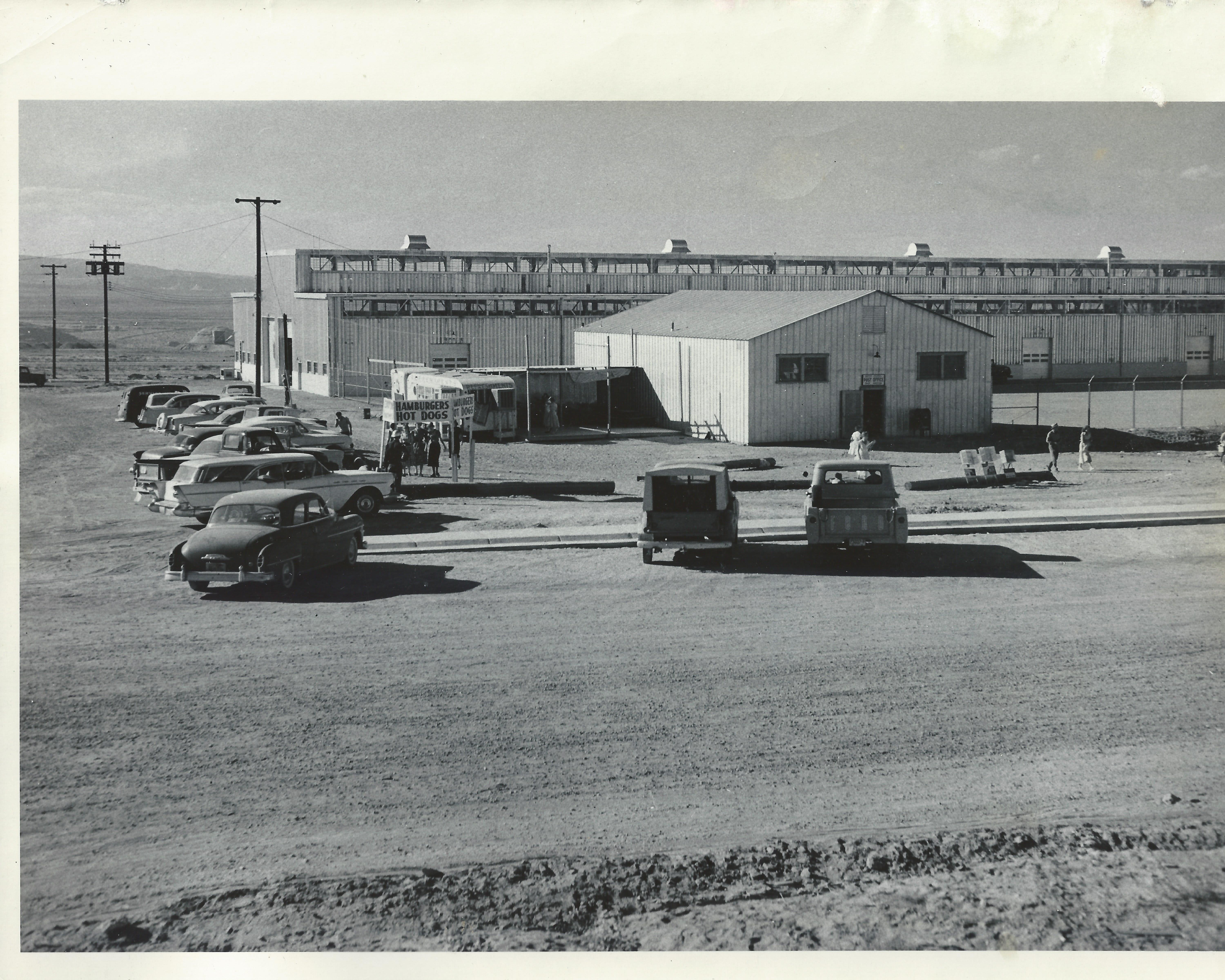
Hamburgers and Hotdogs

Photo: J. L. Digby, USBR 10/6/1958 Courtesy of the LeGate family.
Photo: J. L. Digby, USBR
10/6/1958
Courtesy of the LeGate family.

This picture, dated 1/6/1958 is another view of the post office with the USBR warehouse behind it. The warehouse is still there, but this post office is long gone. The Windy Mesa was eventually built just to the right of where this post office sat, on North Navajo Drive. This picture was taken from the approximate location of present day Stromboli’s. The fire station and old USBR ranger station were to the left of this picture. I did a separate post about this post office building [HERE]. Now I know where it was located.

I’m not sure if the hamburger and hotdog stand was a regular event, or if there was something special going on this day.

-Mike

Where’s Waldo?

Photo: A. E. Turner, USBR 2/28/1964 Courtesy of the Legate family.
Photo: A. E. Turner, USBR. Dated: 2/28/1964
Courtesy of the Legate family.

This picture is a real prize. There is no caption on the back, so I don’t know what event was going on that prompted this. Before we talk about the faces in it, let me set the location for you.  This is in the intersection of South Navajo and 7th Avenue (Lake Powell Blvd). The Pink Sans is behind the camera and this view is toward the football field. The opening in the chain link fence to the right of the tree was the entrance to the football field. Do you see the stop sign on the right side? That’s South Navajo Drive. We had no traffic signals. Most corners had yield signs and some, like this one, had a stop sign. Do you see the (not-so-grand) grandstands near the center of the picture? The goal posts are also visible, the north one more so. To the left of the grandstands is the old snack bar and further to the left, you can see the scoreboard. It’s that rectangular black thing about 15 feet off the ground. I’ll have more to say about that in a different post.

Behind all of the football field stuff, you can see the old teacher’s apartments. These were along church row. This is also a good shot of LeChee Rock in the distance. Hmmmm, no power plant…

Now for the good stuff. Were you in this picture? Do you see yourself in this shot? If so, and you want to ‘fess up, please do. I need some help here. I looked for myself in it, but I can’t find myself (that sounds like a U2 song!). What was happening here? I suspect it was the beginnings of a parade, but that’s just a guess. Page was big on parades back then. This picture was taken from an elevated platform and the woman taking the other picture is on a different platform. Maybe they were parade floats. I don’t know.

Let’s look at some names. I’ve been able to identify a handful of the people in this. A few were my classmates, but I’m not sure where I was. Here’s what I have so far:

  • My half brother is the one in front between the two guys waving their hands.
  • Don Diamond
  • Larry Patterson
  • Jim Garber
  • Larry Sanderson
  • Theresa Kocjan
  • Marla Kocjan
  • Nancy Mayes (?)
  • Darryl Diamond
  • Larry Sanderson’s sister. I don’t remember her name for sure. Maybe Gini?
  • The woman with the camera may have been Mrs. Patterson.
  • There are several other faces that I recognize, but the names escape me.

If you were in this picture and/or can tell us what was going on that day, please leave a comment below.

-Mike

Manson Mesa Pool

Manson Mesa Pool Under Construction 10/6/1958
Photo: J. L. Digby, USBR
Courtesy of the LeGate Family

Who remembers the Manson Mesa Pool? I sure do. I spent many hours in that pool on those long, lazy summer days. I even spent a lot of time in it after it was closed down and drained. But that’s another story for another time. This photo is dated 10/6/1958 and the back caption simply reads, “Swimming pool.”

The Manson Mesa Pool was located on South Navajo Drive, adjacent to the park, on the corner of Seventh Avenue (now Lake Powell Blvd) and South Navajo. This photo was taken from near the curb of South Navajo, looking north-ish, parallel to Seventh Avenue. The Pink Sans Drive-in is (or soon will be) to the right of this picture, across Seventh Avenue. The park will be to the left of the picture. The brick building in the distance, just to the left, is the Page Hospital. It appears to be under construction in this photo. The white building to the left of the hospital is the USBR HQ that I blogged about in a previous post. I don’t know who the worker is in this picture.

There is no evidence today that this pool ever existed, much like the old drive-in theatre. Progress?

-Mike

The Crane! The Crane!

19
Photo: A. E. Turner, USBR
7/21/1958
Courtesy of the LeGate family.

This photo had some water damage, so I’m glad I was able to scan it. It’s dated 7/21/1958 and the handwritten description on the back reads, “Tower for cableway under construction.” This was one of three towers on this side of the canyon that rode on railways. This one may have been in a fixed position. I don’t remember for sure. There were three more on the Page side of the canyon. Cables spanned the canyon from these towers and were used to dump concrete, move material, and transport workers into and out of the canyon.

This one is shown on what is today, the upper parking lot of the Visitor’s Center. The Visitor Center itself would eventually be built to the left of this picture.

-Mike

USBR Offices

Photo: J. L. Digby,
USBR 10/6/1958
Courtesy of the Legate Family

I appreciate the clean look of this photo, dated October 6, 1958. The handwritten back caption reads, “Municiple buildings where big cheeses from Bureau work.” If you live in, or have lived in Page for any length of time, you probably recognized this building right away. It sits on the corner of North Navajo Drive and Vista Avenue. If you type Page Arizona into Google Earth and go to that intersection, you’ll get a good look at how it appears today.

In addition to the USBR administrative offices, this building has also been the Page Municiple building and courthouse and the National Park Service headquarters. I seem to remember the library being in there too, but I may be having a senior moment. Can somebody help out a brother here? If you remember, let me know.

The fact that there is no other development anywhere in this picture makes it that much better. I like that North Navajo Drive is still dirt. Vista Avenue is to the right in this picture and today, the Page hospital sits across the street (Vista Ave) to the right of the photo. Did I mention that I like the pickup truck on the far right side?

-Mike