Photo: A. E. Turner, USBR 8/6/1958 Courtesy of the LeGate family.
The back caption on this photo dated 8/6/1958 reads, “Men working on bridge. View point for visitors in background.” I’ve mentioned the old visitor’s center and the lookout point in a few of my previous posts. You can see the parking lot in the background on the Page side of the canyon in this picture. Access to the parking lot and lookout was from US 89, just above this photo. The camera angle is pointing almost directly to Manson Mesa and Page.
You can see the walkway coming off the right side of the parking lot. It looped back to the covered lookout point below the parking lot. You can see some people there (just in front of the guy in white) taking advantage of the good view. Yours truly took advantage of that view countless times too. The guy at the bottom of the picture looks like he’s carrying something pretty heavy. The guy in front of him looks to be texting. 🙂
This picture looks to have been taken just past the center of the bridge on the Page side of the bridge as you can see the arch beginning its downward slope on the left toward the canyon wall. You can get good look at the net below too.
Manson Mesa Pool Under Construction 10/6/1958 Photo: J. L. Digby, USBR Courtesy of the LeGate Family
Who remembers the Manson Mesa Pool? I sure do. I spent many hours in that pool on those long, lazy summer days. I even spent a lot of time in it after it was closed down and drained. But that’s another story for another time. This photo is dated 10/6/1958 and the back caption simply reads, “Swimming pool.”
The Manson Mesa Pool was located on South Navajo Drive, adjacent to the park, on the corner of Seventh Avenue (now Lake Powell Blvd) and South Navajo. This photo was taken from near the curb of South Navajo, looking north-ish, parallel to Seventh Avenue. The Pink Sans Drive-in is (or soon will be) to the right of this picture, across Seventh Avenue. The park will be to the left of the picture. The brick building in the distance, just to the left, is the Page Hospital. It appears to be under construction in this photo. The white building to the left of the hospital is the USBR HQ that I blogged about in a previous post. I don’t know who the worker is in this picture.
There is no evidence today that this pool ever existed, much like the old drive-in theatre. Progress?
Photo: A. E. Turner, USBR 7/21/1958 Courtesy of the LeGate family.
This photo had some water damage, so I’m glad I was able to scan it. It’s dated 7/21/1958 and the handwritten description on the back reads, “Tower for cableway under construction.” This was one of three towers on this side of the canyon that rode on railways. This one may have been in a fixed position. I don’t remember for sure. There were three more on the Page side of the canyon. Cables spanned the canyon from these towers and were used to dump concrete, move material, and transport workers into and out of the canyon.
This one is shown on what is today, the upper parking lot of the Visitor’s Center. The Visitor Center itself would eventually be built to the left of this picture.
Photo: J. L. Digby, USBR 10/6/1958 Courtesy of the Legate Family
I appreciate the clean look of this photo, dated October 6, 1958. The handwritten back caption reads, “Municiple buildings where big cheeses from Bureau work.” If you live in, or have lived in Page for any length of time, you probably recognized this building right away. It sits on the corner of North Navajo Drive and Vista Avenue. If you type Page Arizona into Google Earth and go to that intersection, you’ll get a good look at how it appears today.
In addition to the USBR administrative offices, this building has also been the Page Municiple building and courthouse and the National Park Service headquarters. I seem to remember the library being in there too, but I may be having a senior moment. Can somebody help out a brother here? If you remember, let me know.
The fact that there is no other development anywhere in this picture makes it that much better. I like that North Navajo Drive is still dirt. Vista Avenue is to the right in this picture and today, the Page hospital sits across the street (Vista Ave) to the right of the photo. Did I mention that I like the pickup truck on the far right side?
Photo: A. E. Turner, USBR 9/15/1958 Courtesy of the Legate Family
Here’s a shot looking down on the conveyor belts that transported the gravel underground to the batch plant. It’s dated 9/15/1958. There is a hand-written caption on the back that reads, “Concrete batching plant and concrete aggregate piles. Aggregate goes to tunnel and conveyor belt below piles and took to top of plant.” If you enlarge this and look close, you’ll see a gravel truck approaching what I believe is the dump hopper.
On the right side of the photo near the top, you can see where the canyon wall has been excavated in preparation for the dam. You can also see the spillway cut out on the far side of the canyon. You can also see the anchor point for the bridge arch on the Page side. Just to the right of this picture is the present day Visitor’s Center.
You can also see the footbridge and its shadow being cast down the canyon wall near the center of the picture.
Photo: A. E. Turner, USBR Courtesy of the LeGate family.
This photo is dated 7/8/1958. The back reads, “Foot bridge. The diversion tunnel inlet can be seen at bottom of canyon on right.”
As I scoured this with my handy-dandy magnifying glass, I noticed about a dozen people walking across the footbridge. As was stated on the back of the photo, you can see one of the diversion tunnels at the bottom of the canyon. These were used to divert the Colorado River water around the dam site during construction.
In the distance you can see a very dry Wahweap Bay and Castle Rock. It looks like this picture was taken from on the Beehive. It would be cool to find that spot and take another picture today of this same angle. This may have been taken before they sheered off the side to make room for the railways that supported the cable cranes. And you thought the flattened side of the Beehive was there to make room for the Visitor’s Center, didn’t you. The dam sight is just to the right of this picture. Stay tuned…
Page Arizona, 1957-58. Source: USBR. Photo courtesy of the LeGate Family
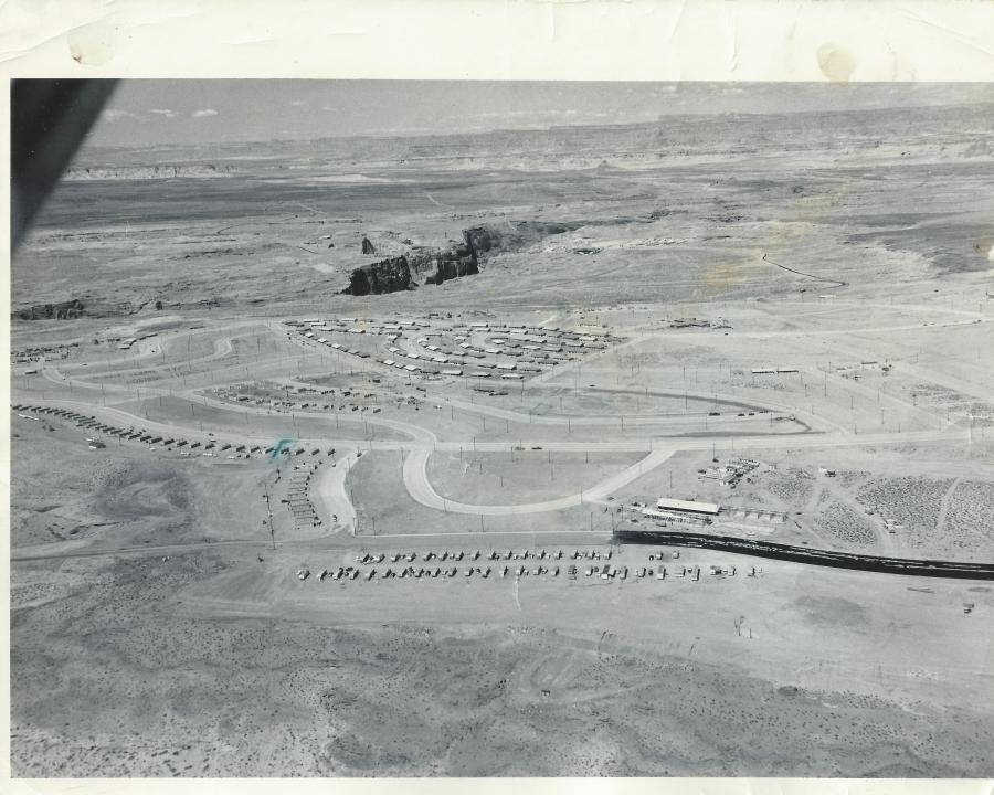
This fantastic aerial shot of Page is undated, but I think it’s safe to place it in the 1957-58 time frame. The original photo is an 8×10 with the following hand written on the back by Gene C. Legate (unedited),
“Gov’t houses under construction. Ours [Legate’s] is 4th house from right end of the line of houses which extend from middle of picture to left toward middle of picture. Other place marked is where we’ll move to shortly. Black road is fresh oil which is put on before asphalt is placed on it. The first 100 houses shown are near completion. The second 100 are now about finished and are in the two blocks below first 100. Dam site in exposed canyon. Temporary school at lower right under construction.”
There is a lot going on in this picture that I would like to talk about. Let’s start at the bottom of the picture. I don’t remember the two lines of mobile homes at the bottom along 7th Avenue (now Lake Powell Blvd), but they are sitting on the approximate location of the Catholic Church. I think there’s a tennis court there now too. The temporary school buildings across the street from the mobile homes referenced on the back of the picture, became the X and Y buildings where I started 1st grade in Mrs. Frye’s class. I have a street-level picture of those buildings, and a story to share with you at a later date. The circular road next to the X and Y buildings was the drive through where buses and parents would drop their kids off for school. I remember it well. That road’s been gone a long time and is now baseball fields, I believe. The high school football homecoming bonfires used to be held in that area.
The row of buildings along the street next to the drop-off loop, that continue on to South Navajo Drive, were the transit (transa?) houses. I think these were originally put there as temporary housing for some of the USBR employees. Someone help me out here if you have more info for us. What I do remember is that they were a bright pink color and they were there for years. Do you see the green pen mark next to the 4th one along Navajo Drive? That is the one referenced in the description on the back of the picture as being where the LeGate family lived for a time. It’s hard to see, but if you enlarge the picture, you’ll see a green square drawn on Cedar Street, also referenced on the back of the picture as “the place…we’ll move to shortly.”
Page Arizona Post Office 1958. Source: LeGate Family
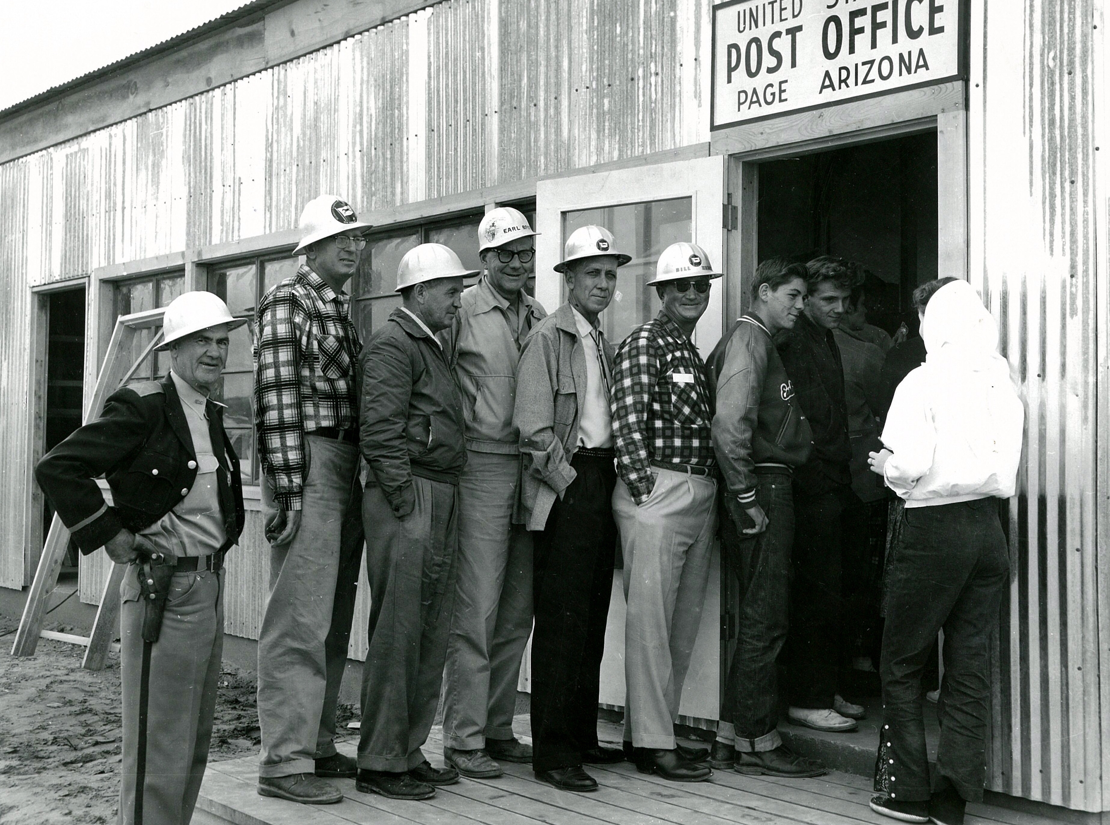
This amazing picture was sent to me yesterday by a friend (thank you Gene!). I don’t know who took it or why, but it’s one of my favorites. It’s the Page Post Office in 1958. This was taken 1 1/2 to 2 years before we moved there and I don’t recognize anyone in it. I think it’s interesting that the young guys are talking to the girl, but the older guys are all about the camera, except that one guy. There’s always that one guy.
This building was located next to the USBR warehouse on North Navajo. across the street from present day Stromboli’s. I am curious to know why there was such a line out the door on this day. Nobody seems to have anything to mail. Maybe it was a rush on forever stamps or maybe there was free wifi. But I doubt it.
The 3 Butler Buildings that housed Page schools in the late 1950s
These are the Butler buildings that served as the Page schools from 1958-1959 or 60. The permanent school was under construction and completed about 1960. These three buildings were located on the curve of South Navajo Drive. You can get a better feel for where they were located by looking at the bottom center of the aerial picture I posted [here].
The permanent school buildings were completed in 1959-60 and are located on South Navajo Drive, across from the Date Street intersection. These were originally called the A, B, C (Gym), and D buildings.