Source: Terry Edwards Date and Photographer Unknown
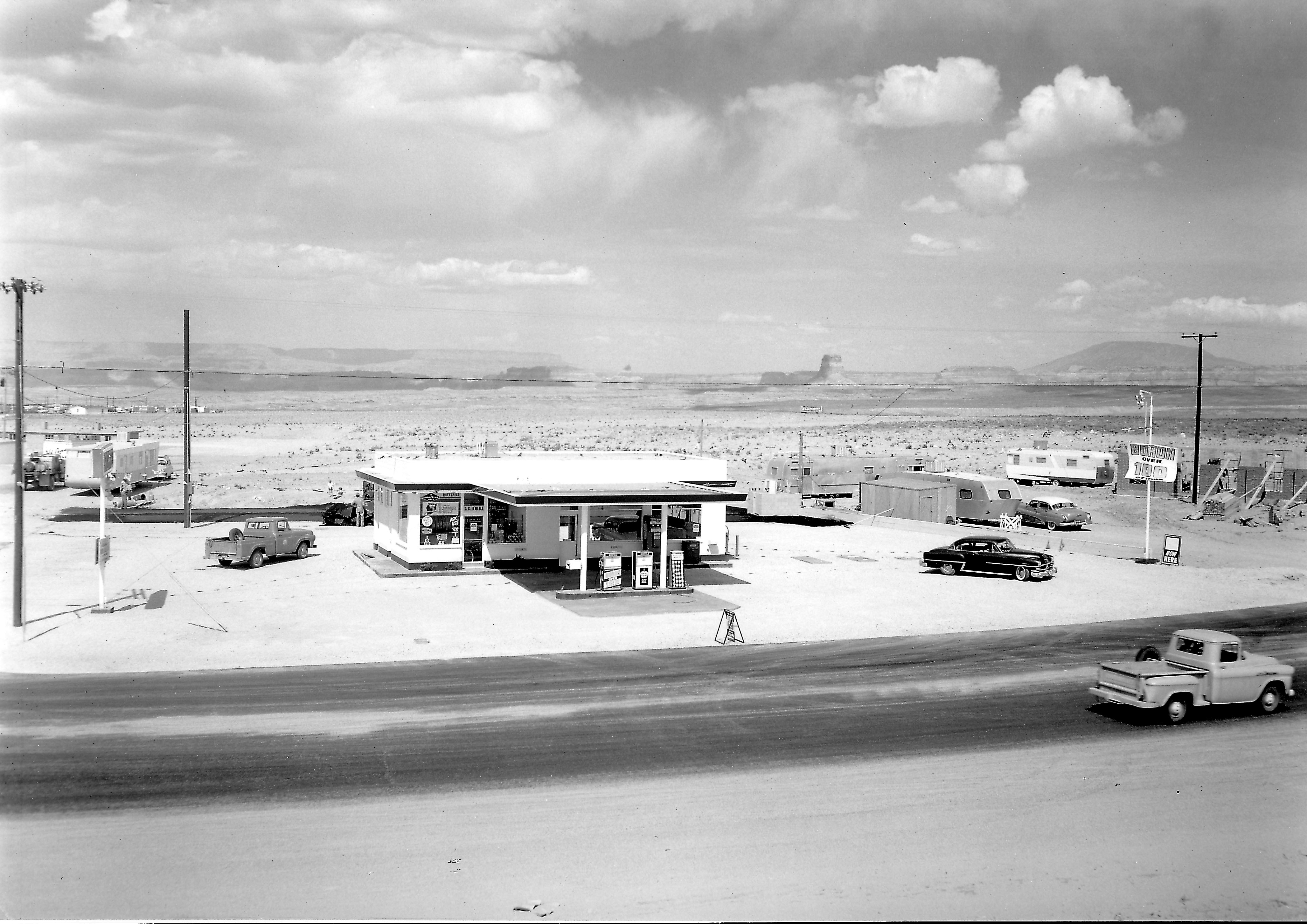
This first picture looks like something out of a Normal Rockwell painting. My first thought was that it was the original Exxon (Enco) gas station on the corner of 7th Avenue and Elm, but the wall under construction on the right side of the photo would have to be the Empire House, and that’s not the Empire House. Plus, other pictures of the old Exxon station show a completely different layout with two garage bays on the left side of the building. That’s how I remember it.
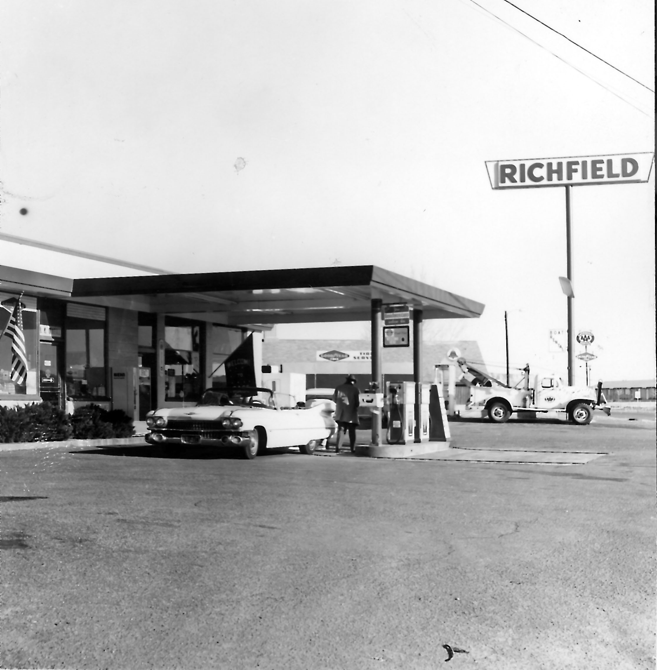
After digging a little further, I realized this is the old Richfield station that was on the corner of South Navajo and 7th Avenue (Lake Powell BLVD). You can see 7th Avenue starting to curve toward church row. The building under construction on the right is the First Baptist Church. The last time I was in Page, this gas station had been turned into a fast food restaurant. The quality of this photo is amazing. So are the two pickup trucks! The MCS apartments are visible on the left behind the small trailers. It looks like they’re under construction. The white building further back is probably the American Legion building and beyond that, the original trailer court. This is a good shot of Tower Butte and Navajo Mountain in the background. I’m not sure what that billboard says in the background. Even zoomed in, I can’t read it.
The bottom picture is of the same building some time later. I wonder if the Cadillac was pink. Neither picture is dated and I don’t know who the photographer was.
Source: Terry Edwards Date and Photographer Unknown
Photo: USBR, date and photographer unknown. Source: Terry Edwards
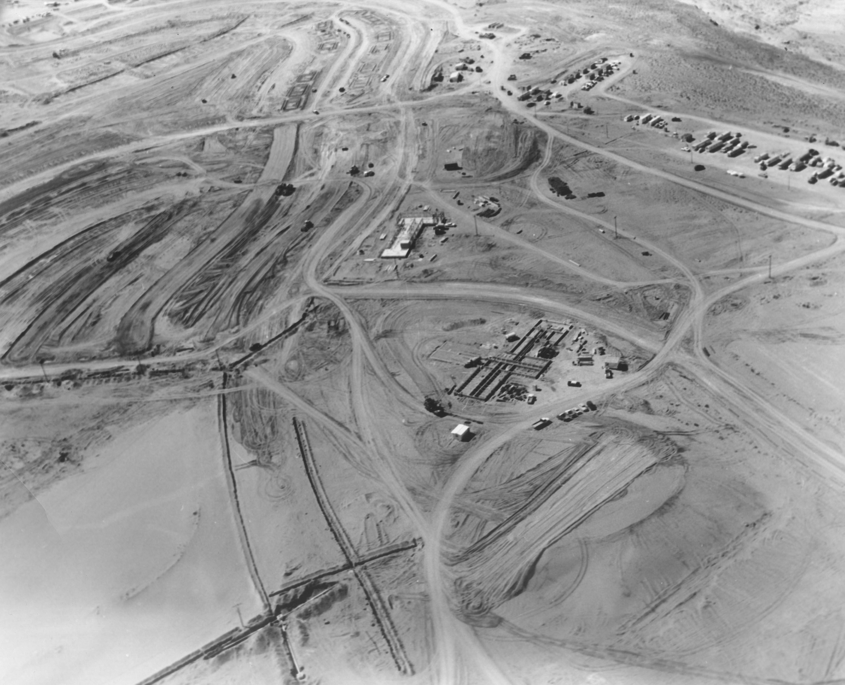
It took me a few minutes to figure this one out, but I eventually did. I’m not the sharpest knife in the drawer, so that explains a lot. This first pic is an early shot of two of the first buildings that went up in Page, if not THE first two.
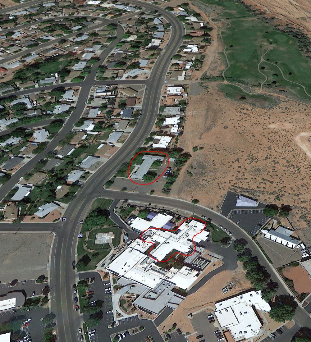
There weren’t any landmarks in the picture to go by, so it kind of leaves you on your own. Give up? This is the corner of Vista Ave and North Navajo Drive. The larger building is the hospital and the smaller building originally served as the USBR admin building. It’s been a number of other things since then. I talked about it and shared a really nice photo of it with you in a previous post [HERE]. Be sure to click that link if you haven’t already seen it. It’s worth the click! The dirt road between the two buildings is Vista Ave. The nicely graded road to the left is Gum Street. For reference (and because I have awesome moments) the picture below is how that same area looks today. I rotated it to match the angle of the picture above as much as possible, and I circled the same two buildings. The hospital’s grown from it’s original size, so the area I circled is the original footprint of the building.
Photo: A. E. Turner, USBR Undated Source: The LeGate Family
This photo is undated, but I think it must be 1957ish. The handwritten caption on the back reads,
“In bottom of canyon upstream from bridge. Concrete form for diversion tunnel shown here. To the bottom left is tunnel (mile plus long) which will connect the power house to top of canyon wall and to Page.”
There are a couple of things that need pointed out on this photo. The writing I cited above mentions a diversion tunnel and a tunnel that goes to the top of the canyon wall. Those are two different things. The opening mentioned on the left of the picture is the bottom of the tunnel that runs from there to the top of the canyon and comes out behind the old Country Club an golf course. That tunnel is still in use. The lower opening to the tunnel that you see in this picture is now on the downstream side of the dam and comes out near the power house. The next time you’re there, look down and you’ll see it. It’s interesting that the back caption says this tunnel WILL connect the top to the bottom, as it was still under construction at the time of this photo.
The concrete form mentioned in the picture is the round object on the right. There were two diversion tunnels that re-directed the Colorado River water around the dam site during construction. In future posts, I’ll be sharing some pictures with you of construction inside those diversion tunnels, as well as the upper spillways which connected to the diversion tunnels.
Notice the roadway in the center of the bridge and the road protruding out from the canyon on the right side. The present-day visitor’s center is located on the right side of this picture by the road. Also notice the netting that hung off the bottom of the bridge to catch falling workers and material. The cables that spanned the canyon are clearly visible and it looks like there is another roadway support being set at the time of this photo. This view is long gone!
Photo: F. S. Finch, USBR 4/27/1957 Source: The LeGate Family The back of the photo reads, “Small tunnel in keyway. Used for what I don’t know.”
These are great shots of some unidentified workers in random tunnels in the rock around Glen Canyon Dam. The captions below the pictures tell you what was written or stamped on the back. I don’t know what these tunnels were used for, or if they’re still there. Enjoy!
Photo: A. E. Turner, USBR 1/30/1958 Source: The LeGate Family The back of this photo simply reads, “Tunnel in Keyway.”
That was then. Source: Dugan Warner. The photographer is unknown, but this is most likely a USBR photo. It’s undated.
I have to confess, I spent a lot of time pouring over this top picture and then I had this brilliant idea to grab a current day photo and compare. Yes, I have moments of brilliance. But they’re short lived.
This post has two photos. The one above was then and the bottom one is now. The top picture was taken before time began. That’s an exaggeration, but it’s not too far off. It’s a high altitude photo of the Colorado River at the Glen Canyon Dam site. There is nothing there but a muddy river. The soon-to-be city of Page is outlined in the dotted area. Wahweap creek is visible (and empty) at the bottom right. The beehive is plainly visible, but this was clearly taken before any work on Glen Canyon Dam or the city of Page had begun.
When you’re done with the top photo, look at the “now” picture below for comparison. I want to thank Dugan Warner for supplying the top photo to me so I could share it with you. Enjoy!
This photo is undated but is in the late 1950s. The photographer is not identified. Source: Dugan Warner
One of my first posts on this site was of a couple of highscalers belting off before going over the edge of the canyon. Here’s another one for your visual enjoyment! I’ll make a few comments below.
I don’t have the date this picture was taken, or any information about the photographer, but it was most likely a USBR photo. I can’t imagine who else would have gone over the canyon wall with these guys to get this shot. If you zoom in on this picture, you’ll see that they are using a drill of some kind to bore holes for anchors into the canyon wall. A square end plate was attached to the anchors (if that’s what these holes were for) to strengthen the sandstone wall and help keep it intact. These could have been something else, but that’s my best guess. They’ve already anchored several that look ready to be finished. Notice the 2 x 12 platforms – one below them and the other nearer the photographer. The photographer’s probably standing on that one.
This picture was taken from the Page side of Glen Canyon, looking downstream. Glen Canyon Dam is behind the photographer. A special thanks goes out to Dugan Warner for getting this picture to me.
Glen Canyon Dam lower footbridge under construction. 1958? Source unknown.
Who remembers this? If you take a look at my last post, you’ll see a portion of this footbridge near the bottom of that photo. It spanned the lower part of the canyon at the approximate location of the present-day powerhouse. This picture is taken from the Page side at the bottom of the canyon. The powerhouse tunnel exit is behind the photographer and to his left. This is a good shot of the canyon wall at the spot where the dam now sits.
The footbridge is still under construction on this photo. Either that, or you had to get a running start to make it across. This picture is undated and I don’t remember now where I got it. But due to its quality and the fact that it’s black and white, I’m guessing it’s a USBR photo and that it was taken around 1958. But that’s just my best guess. If anyone can give me more info on the history of this bridge, please do.
Photo: A. E. Turner, USBR 9/10/1958 Source: The LeGate Family
The building of Glen Canyon Dam and Bridge wasn’t accomplished without great personal loss by some. I’m posting two photos this time because they are closely tied to one another. The handwritten caption on the back reads,
“Lower end of diversion tunnel and adit for powerhouse tunnel road. Right above the adit is where the man got killed Aug 11th. Rock ledge 200 feet above adit broke off. Small footbridge across river is at lower left.”
You can clearly see the lower opening to the powerhouse tunnel mentioned in the picture. It’s located at the base of the dam, next to the powerhouse. The lower footbridge mentioned in the caption and visible in the photo was at the approximate location of the powerhouse. My next post will be a better look at that lower footbridge. The powerhouse tunnel runs along the inside of the canyon wall from behind the old Country Club/golf course on top, to this point below. It’s still in use. The adits mentioned in the caption are the smaller horizontal tunnels that intersect the main tunnel at 90 degrees at regular intervals, primarily for ventilation. If you scroll back up to the picture, you’ll see the adit that is mentioned in the caption.
The photo was taken or cataloged one day short of a month following a fatality at this location that occurred on 8/11/1958. The photo caption mentions that a rock ledge broke off above the adit and killed a man. According to the memorial plaque below, the individual’s name was Austin Merritt. He joins 17 others who lost their lives in the Glen Canyon Dam project. All of them are listed here:
This memorial lists the names of the 18 individuals who lost their lives during the construction of Glen Canyon Dam and bridge. Source: Wmpearl (Own work) [CC0], via Wikimedia Commons
The above memorial plaque was created by WMPearl in 2011 and is posted on Wikimedia Commons. I don’t know where it physically resides. Click [HERE] to view the source website at Wikimedia.
In the early 1970’s, one of my friends told me that her father was killed during the building of the dam. His name is listed at the top of the middle column, Raymond D White.
UPDATE 5/24/17: Here’s a list of memorials of the names on the plaque compiled by Donna Bloxton Petersen. Thank you Donna for all the time and work you put into this!
Photo: J. L. Digby, USBR 10/6/1958 Courtesy of the LeGate family.
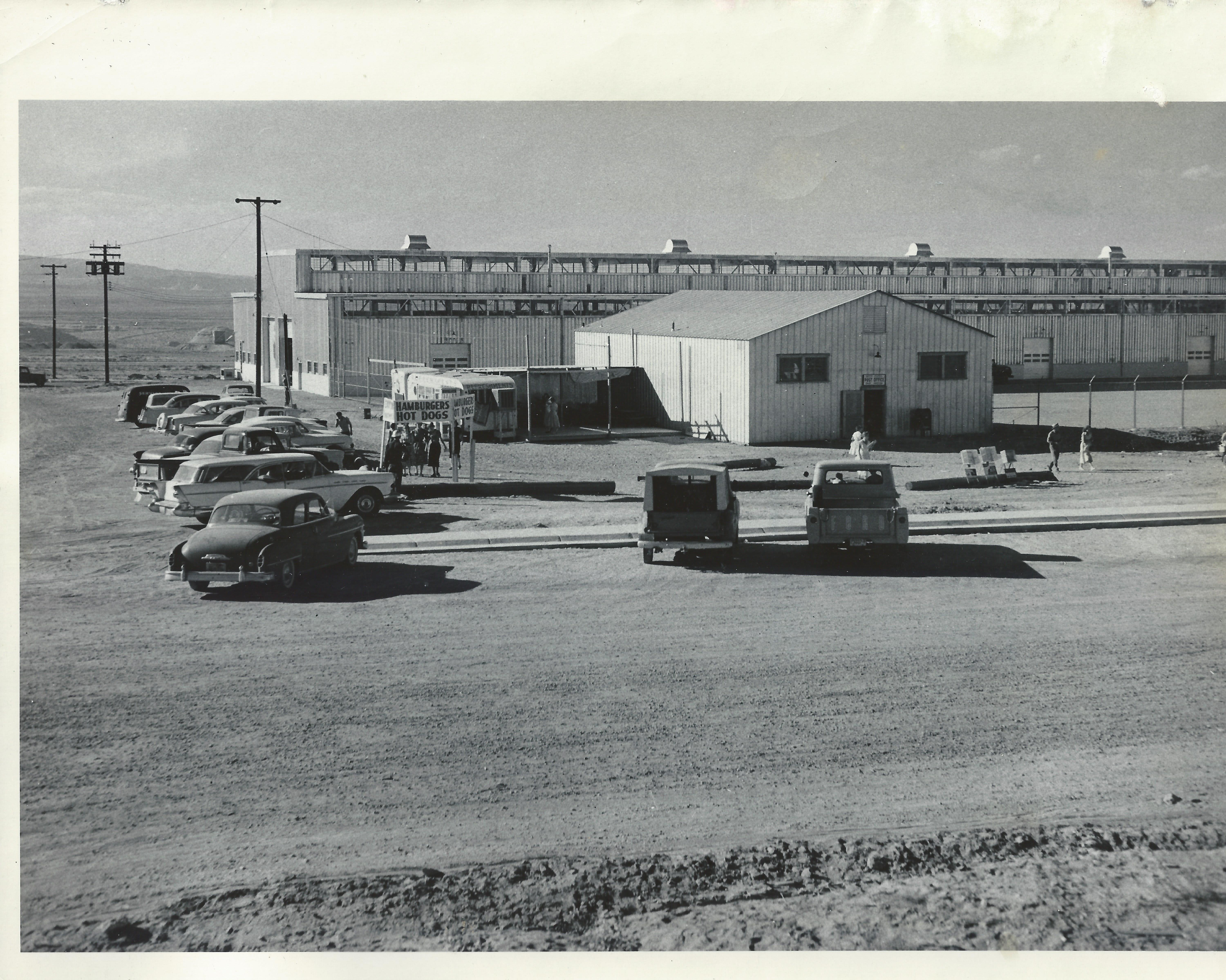
This picture, dated 1/6/1958 is another view of the post office with the USBR warehouse behind it. The warehouse is still there, but this post office is long gone. The Windy Mesa was eventually built just to the right of where this post office sat, on North Navajo Drive. This picture was taken from the approximate location of present day Stromboli’s. The fire station and old USBR ranger station were to the left of this picture. I did a separate post about this post office building [HERE]. Now I know where it was located.
I’m not sure if the hamburger and hotdog stand was a regular event, or if there was something special going on this day.