The Beehive Then and Now

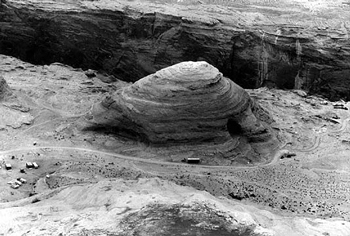
The Hive as it looked then….

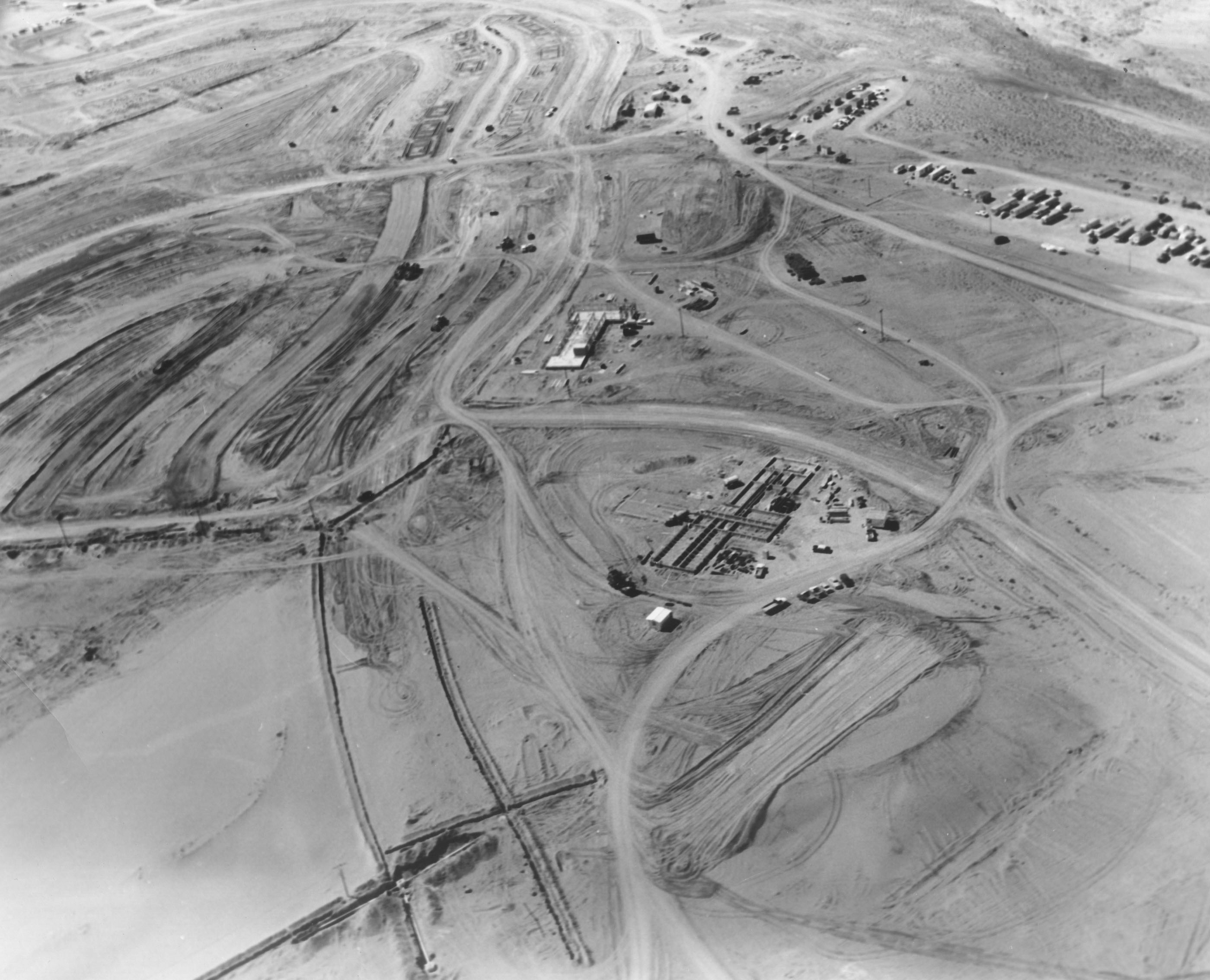
The Beehive as it appeared in this 1950s photo, showing preliminary construction of Glen Canyon Dam and Bridge. This photo is undated.

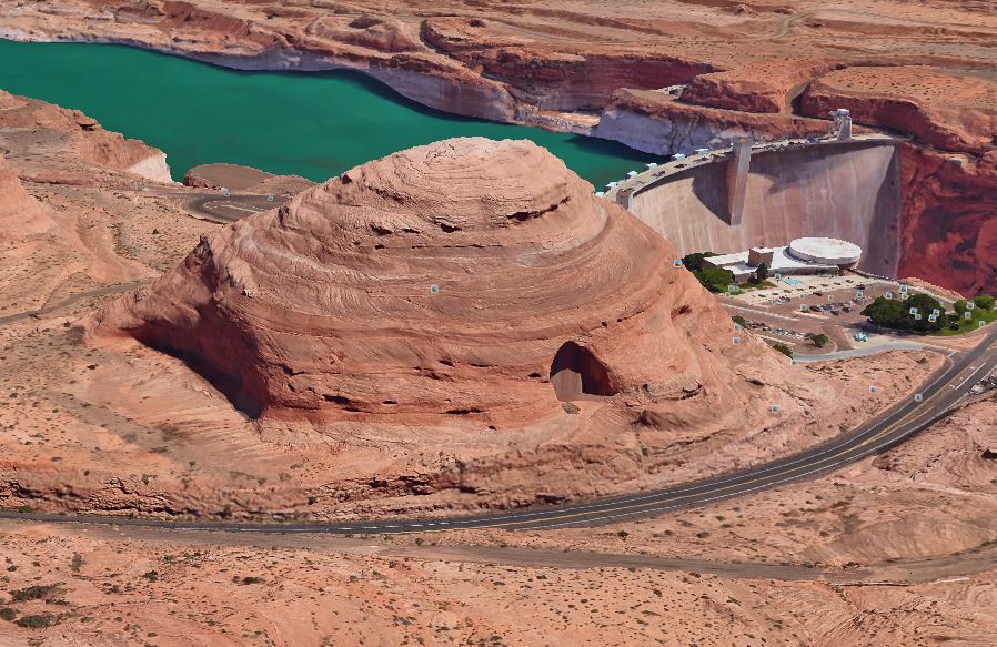
The Hive as it looks now…

The Beehive as it appears today. The upper parking lot of the Visitor Center (on the far side of the Beehive) is where the rail-mounted crane towers were located. They were used to lower buckets of concrete into the canyon as well as moving equipment and personnel into and out of the canyon.

The early, undated photo of the Beehive at the top shows preliminary work underway for the Glen Canyon Bridge and Dam. I can’t tell if the east side has been cut away yet. The second picture is one I captured on Google Earth for comparison. I love putting together these then and now pics when I come across them. I’m close to brilliant! 🙂

Be sure to check out my Facebook page at: https://www.facebook.com/pageaz/

-Mike

Glen Canyon Dam Construction Site

Photo: A. E. Turner, USBR. Source: Terry Edwards

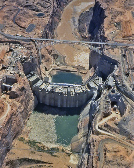
Here’s another aerial view of the Glen Canyon Dam construction site. This is looking upstream toward Wahweap creek. It’s a good look at the coffer dam, the early stages of the dam itself, and the power plant. The crane towers are visible on each side of the dam. If I remember right, there were two 25-ton towers and one 50-ton tower on either side. These crane towers moved back and forth along tracks. The road down to the visitor lookout site is visible on the right side of the canyon, coming off of US89. The oval shaped area was the parking lot and you can see the walking trail down to the lookout point. The footbridge is faintly visible in this photo too.

Lake Shore Drive, which was still dirt, is clearly visible. It was built and used for hauling gravel to the concrete batch plant at the dam site. Aggregate was trucked in to the batch plant from Wahweap Creek and dumped in an underground hopper at the base of the conveyor belt, visible in this picture near the end of the road. The aggregate was processed and conveyed to the concrete mixing plant seen in this picture on a large shelf cut out of the canyon wall. That concrete mixing plant was about twenty stories tall. The mixed concrete was dumped into a rail car that in turn, dumped the concrete into the buckets suspended by the cranes, for their trip to the topmost section of the growing dam. That’s the abbreviated story of the process. I always wanted to go inside that mixing plant but I never got the chance. Click on the image to enlarge it. Download it and check out the detail.

Enjoy!

It’s a Dam Site

Glen Canyon Dam Construction, 1962 or 63. Source unknown.

There’s a lot of good detail in this photo.It’s a good look at both spillways and the temporary coffer dam at the bottom of the picture. The concrete batch plant is visible on the canyon edge to the right. Water is visible exiting the right diversion tunnel, but not the left. The left diversion tunnel inlet was about 33 feet higher than the right tunnel inlet and was intended to be used only during high river flows. The parking lot for the lookout point is visible on the left, just above the bridge. The rectangular building along the highway on the left side of the bridge was the original visitor’s center. It was later moved into town and became the LARC center. I don’t remember what that acronym means. The rail-mounted cranes are visible on either side of the canyon. There were two 25-ton cranes and one 50-ton crane on each side. In addition to transporting buckets of concrete to the dam, these cranes were used to transport people and equipment in and out of the dam site. Near the bottom right corner of the picture, you can see the tower structure holding the footbridge, and the footbridge is visible too. The dark area by that tower, that curves around the sandstone knoll, was the road/parking lot for the footbridge. You can still see the remnants of that road on Google Earth. Go take a look.


Enjoy!

Mike

1960s Aerial View of Page Arizona

Source: Terry Edwards. Date and photographer unknown. Most likely USBR.

Here’s a 1960-ish shot of Page and the surrounding area from the seat of a plane. If you click on it, it will open it up in a new tab and enable you to zoom in closer. All of my pictures work that way. You’re welcome. 🙂  Enlarge it and let’s talk about some of the detail.

Starting on the bottom left, you’ll see the original radio station (KPGE) just off the old Coppermine road. I don’t remember what the building between it and the water treatment plant was. If you do, please leave a comment and let me know. I posted pictures of the water treatment plant already in a post I called Got Water? You can check it out >HERE<. Next to the water treatment plant is the go-cart track and the Little League baseball field. If you look at that area on Google Earth, you can still see remnants of the go-cart track. That’s actually the second location of the baseball field. The first one was behind Keisling’s gas station and The Bottle Stop (now Stix Market). The outline of it is still visible in this picture. You can see that original field better >HERE<.

Moving up from the water treatment plant, you’ll notice that Chapman’s trailer park isn’t there yet. Several church buildings are dotting the landscape along church row (7th Avenue – now Lake Powell BLVD). The long buildings on the inside loop of church row were the teacher’s apartments. They may have been under Continue reading →

1959 Aerial Photo of Page, Arizona

1959 Aerial View of Page, Arizona. Photo Courtesy of Terry Edwards.

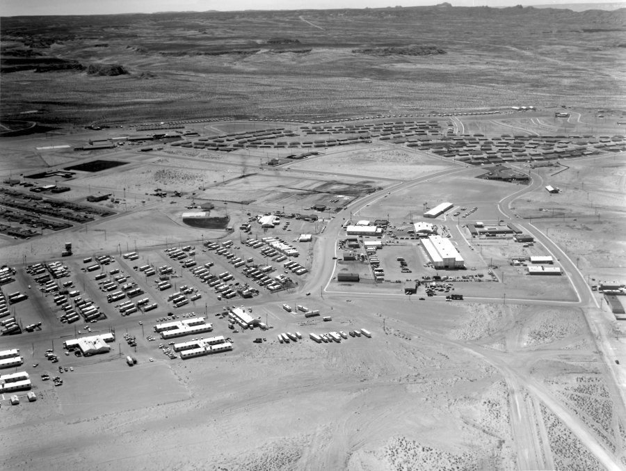
Some of my favorite early pics of Page and the surrounding area are these old black and white aerial shots. You can see a lot of detail and they always bring back memories of what it was like. One of the reasons I’m posting this one is because in my next post or two, I’ll be highlighting some early businesses and I want you to have a reference point for their location if you’re not familiar with it.

We have a lot to talk about in this photo. Click on it to open it up and you’ll be able to zoom in. Let’s start on the right side, as you come into town on 7th Avenue. The Glen Canyon Steak House and Motel aren’t there yet, but it looks like the ground is being cleared for their construction. To the right, along Vista Ave., you get a good look at the Page Hospital and what was at that time, the USBR offices. You can see a close-up of that building and read more about it HERE. You can also see/read more about the hospital HERE. Okay, back to our journey up 7th Avenue. The next building on the left is the Page Boy Motel. The building across the street was the Vostron building and now houses the City of Page offices.

The building across from Vostron on this side of 7th Avenue is the bowling alley. The big rectangle building just this side of the bowling alley is the USBR warehouse. The white rectangle building to the left of the bowling alley in this photo was (is?) the fire station. The smaller building that’s attached to the right end of the fire station was the USBR Ranger station. The only thing I remember being in the Continue reading →

The Lower Water Treatment Plant

I have to admit to not remembering Page’s first water treatment plant being at the bottom of the canyon. When Gene LeGate gave me the first bunch of USBR photos for the blog and I saw these water treatment pics, I was dazed and confused because I could only remember the water treatment plant in town and those photos were completely different. After some research, I surmised that it sat downstream of the dam on the Page side of the canyon. Can’t fool me! What sealed it for me (sort of) was the first photo I’m sharing below that Tim McDaniels gave me that shows the road to it coming out of what must be one of the adits in the canyon wall that now serves as one of the ventilation tunnels for the tunnel that runs from the top of the canyon and to the lower spillway. If that’s incorrect, please let me know. I can take it. I’m still not 100% convinced because some of the background stuff in these pictures doesn’t look right. More on that as we move through them.

This first picture is a shot from above showing the layout of the area. This is the one Tim sent me that pretty much clinched the location. Notice the water line coming over the side of the canyon. That’s the line that brought water to the fledgling town of Page. It’s referenced in another picture below. Notice also the road disappearing into the canyon wall. The handwritten caption on the back reads, “J. Reinhold. 1st water treatment plant for Page.”

Photo: USBR
Date: 5/14/63
Source: Tim McDaniels

Here’s another top down view from a different, closer angle. In this shot, the facility is still under construction. The rectangle building was an electrical switchgear and maybe a pump room. The handwritten back caption reads, “Water pumps and sedimentary tank on river below Page.”

Continue reading →

First Things First

First Buildings
Photo: USBR, date and photographer unknown.
Source: Terry Edwards

It took me a few minutes to figure this one out, but I eventually did. I’m not the sharpest knife in the drawer, so that explains a lot. This first pic is an early shot of two of the first buildings that went up in Page, if not THE first two.

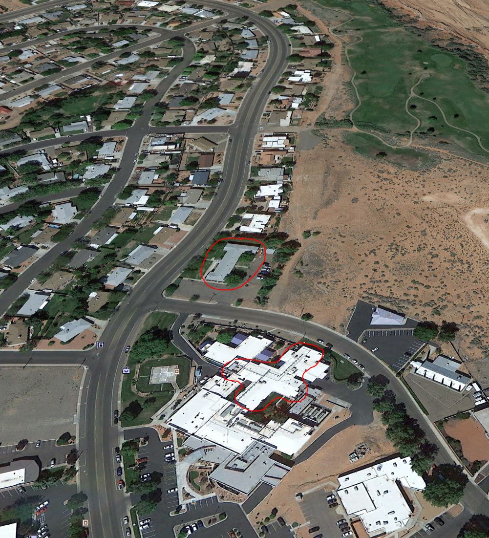
There weren’t any landmarks in the picture to go by, so it kind of leaves you on your own. Give up? This is the corner of Vista Ave and North Navajo Drive. The larger building is the hospital and the smaller building originally served as the USBR admin building. It’s been a number of other things since then. I talked about it and shared a really nice photo of it with you in a previous post [HERE]. Be sure to click that link if you haven’t already seen it. It’s worth the click! The dirt road between the two buildings is Vista Ave. The nicely graded road to the left is Gum Street. For reference (and because I have awesome moments) the picture below is how that same area looks today. I rotated it to match the angle of the picture above as much as possible, and I circled the same two buildings. The hospital’s grown from it’s original size, so the area I circled is the original footprint of the building.

Page Now
The same two buildings are circled in red.

Enjoy!

-Mike

That Was Then; This is Now

Page Town Site
That was then.
Source: Dugan Warner.
The photographer is unknown, but this is most likely a USBR photo. It’s undated.

I have to confess, I spent a lot of time pouring over this top picture and then I had this brilliant idea to grab a current day photo and compare. Yes, I have moments of brilliance. But they’re short lived.

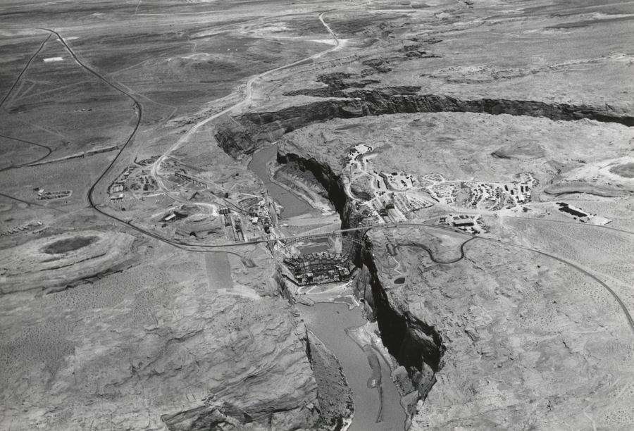
This post has two photos. The one above was then and the bottom one is now. The top picture was taken before time began. That’s an exaggeration, but it’s not too far off. It’s a high altitude photo of the Colorado River at the Glen Canyon Dam site. There is nothing there but a muddy river. The soon-to-be city of Page is outlined in the dotted area. Wahweap creek is visible (and empty) at the bottom right. The beehive is plainly visible, but this was clearly taken before any work on Glen Canyon Dam or the city of Page had begun.

When you’re done with the top photo, look at the “now” picture below for comparison. I want to thank Dugan Warner for supplying the top photo to me so I could share it with you. Enjoy!

-Mike

Capture
This is a present day look at the same area.

7th Avenue From The Air

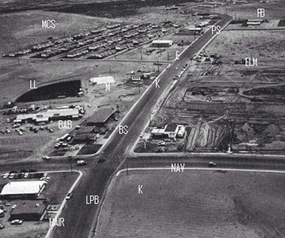
Here’s an aerial shot of Page giving us a good look at 7th Avenue (now Lake Powell BLVD) and some of the early town construction. It’s undated, but 1960-61 is a good guess. I’ve had this photo for a long time and I don’t remember where I got it for sure (maybe Brian Keisling) and I’ve never known who took it or who marked up the different locations. But those are helpful, so let’s run through them.

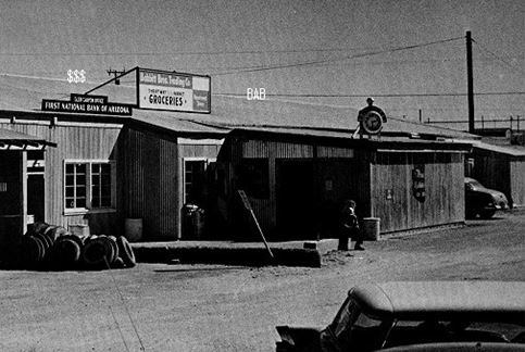
LPB is Lake Powell BLVD (7th Ave). HAIR was the barber shop. I’m assuming the barber was Hank. Does anybody remember him? The barber shop eventually moved to the plaza near the theatre. That plaza isn’t built yet in this picture. K is the present location of the Circle K and NAV is North Navajo Drive. The unmarked building on the corner above North Navajo was a Gulf gas station. We used to ride our bikes there and fill up gas cans for my friend’s mini bike and our golf cart. The building marked BS isn’t a reference to a crappy building, but is referring to Redd’s Bottle Stop. It’s now the location of Stix Market. BAB is referring to Babbitt’s. First National Bank was also in that building. I’m putting a picture of that building below to give you a better look. LL was the Little League field.  M is referring to the outdoor movie screen. K is a reference to Keisling’s gas station. You can see that Elm Street hasn’t been built yet on the right side of LPB. E is referring to the old Empire House. The last time I was in Page, that had become something else but I don’t remember now what it is. My first job as a teenager was as a busboy at the Empire House and my mom was one of the cashiers there for years. MCS is referring to the MCS apartments. PS is the Pink Sans. FB is the future site of the football field. It looks like it’s not there yet in this picture. The buildings just below FB must be the Manson Mesa pool.  You’ll notice South Navajo isn’t there yet either, but you can see part of the park to the right if the pool.  I think the dark line below the pool and the park is a fence. When I first saw this picture, I thought it was a road that is no longer there. But looking closer, I don’t see a break in the curb along LPB, so I’m pretty sure it was one of the many fences put up all over the place to stop blowing sand. They didn’t work too good. Looking along church row, you can see a few churches springing up, along with the teacher’s apartments on the opposite side of the road.

The picture below is a closer look at Babbitt’s and First National Bank, located in the building in the above picture behind The Bottle Stop (Stix Market).

-Mike