Photo: A. E. Turner, USBR 9/15/1958 Courtesy of the Legate Family
Here’s a shot looking down on the conveyor belts that transported the gravel underground to the batch plant. It’s dated 9/15/1958. There is a hand-written caption on the back that reads, “Concrete batching plant and concrete aggregate piles. Aggregate goes to tunnel and conveyor belt below piles and took to top of plant.” If you enlarge this and look close, you’ll see a gravel truck approaching what I believe is the dump hopper.
On the right side of the photo near the top, you can see where the canyon wall has been excavated in preparation for the dam. You can also see the spillway cut out on the far side of the canyon. You can also see the anchor point for the bridge arch on the Page side. Just to the right of this picture is the present day Visitor’s Center.
You can also see the footbridge and its shadow being cast down the canyon wall near the center of the picture.
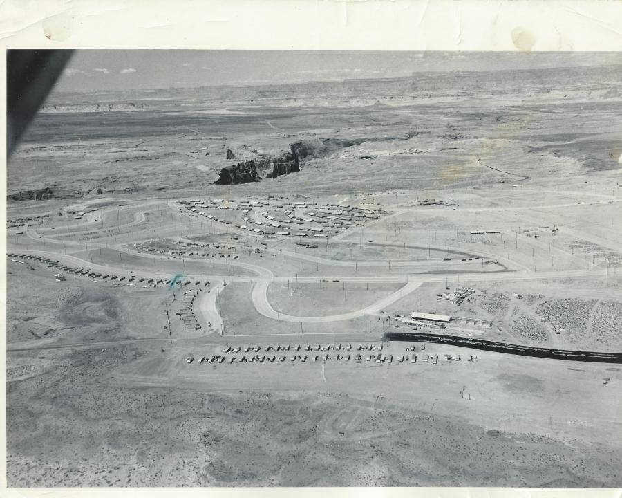
Page Arizona, 1957-58. Source: USBR. Photo courtesy of the LeGate Family
This fantastic aerial shot of Page is undated, but I think it’s safe to place it in the 1957-58 time frame. The original photo is an 8×10 with the following hand written on the back by Gene C. Legate (unedited),
“Gov’t houses under construction. Ours [Legate’s] is 4th house from right end of the line of houses which extend from middle of picture to left toward middle of picture. Other place marked is where we’ll move to shortly. Black road is fresh oil which is put on before asphalt is placed on it. The first 100 houses shown are near completion. The second 100 are now about finished and are in the two blocks below first 100. Dam site in exposed canyon. Temporary school at lower right under construction.”
There is a lot going on in this picture that I would like to talk about. Let’s start at the bottom of the picture. I don’t remember the two lines of mobile homes at the bottom along 7th Avenue (now Lake Powell Blvd), but they are sitting on the approximate location of the Catholic Church. I think there’s a tennis court there now too. The temporary school buildings across the street from the mobile homes referenced on the back of the picture, became the X and Y buildings where I started 1st grade in Mrs. Frye’s class. I have a street-level picture of those buildings, and a story to share with you at a later date. The circular road next to the X and Y buildings was the drive through where buses and parents would drop their kids off for school. I remember it well. That road’s been gone a long time and is now baseball fields, I believe. The high school football homecoming bonfires used to be held in that area.
The row of buildings along the street next to the drop-off loop, that continue on to South Navajo Drive, were the transit (transa?) houses. I think these were originally put there as temporary housing for some of the USBR employees. Someone help me out here if you have more info for us. What I do remember is that they were a bright pink color and they were there for years. Do you see the green pen mark next to the 4th one along Navajo Drive? That is the one referenced in the description on the back of the picture as being where the LeGate family lived for a time. It’s hard to see, but if you enlarge the picture, you’ll see a green square drawn on Cedar Street, also referenced on the back of the picture as “the place…we’ll move to shortly.”
This shot was taken from an old Page High School yearbook and is a downstream look at Glen Canyon Dam in 1961. My apologies for the page crease down the middle. Pretend it’s not there.
It looks like the footbridge is still there. If you enlarge this picture and look close, you can see the posts on either side of the canyon and each end of the bridge. You can also see the shadow it’s casting on the canyon floor just upstream of the dirt dam that’s diverting the river water.
The original visitor’s center is to the left of the bridge on US 89. That building was later moved into town and became the LARC Center, located next to the football field at the corner of South Navajo Drive and 7th Avenue (now Lake Powell Blvd).
The town of Page is clearly visible in the upper left of the picture. The golf course and Country Club can be seen near the top right of the picture, on the far end of the canyon. The small body of water on top of the canyon next to the golf course was the old waste water treatment pond. That’s all I’m going to say about that.
I don’t remember what the large building on the left was, next to the highway. I remember it being there, but I don’t remember what it was. If you can add more info about it, please comment below. The “Add a Page to your Trip” road sign that I mentioned in my first post was located on the highway turnoff to Page at the upper left of this picture.
I remember this stage of the dam construction well. It seems like we ended up out there almost every day, watching the construction progress. At night, there was a flashing “Cocktails” sign on the rim of the town that belonged to a bar on Vista Avenue. I was too young to go bar hopping, but I remember that sign well.
This aerial shot from 1960 or 61 shows the newly completed school buildings along South Navajo Drive at the intersections of Date Street and 5th Avenue. You can see a few church buildings springing up on church row at the top of the picture. Originally, that was called 7th Avenue but was renamed to Lake Powell Blvd a number of years ago. The teacher’s apartments are the long buildings on this side of 7th avenue. They’re no longer there. I guess someone thought it would be a good idea to round up all of the teachers and keep them in one spot for easy handling. Probably not a bad idea. Ha!
Ok, back to the picture. The oval shaped area on the left side of the picture is the football field and track. The bleachers are the small strip next to the field. I have a cool ground shot of the field and scoreboard that I’ll be posting soon. The area behind the bleachers was little more than a big sand pit used for football practice. I remember running wind sprints in full pads in that sand that seemed to be 4 feet deep. I get winded just thinking about it now.
I don’t know how these buildings are referred to now, but they were originally labeled by letter. The larger building on the left was A Building. The small one next to it was B Building (I know, pretty creative!). Both of these building housed the high school. The large building in the middle was the Gym (C Building) and the long one near the bottom was D Building. D Building was home to the junior high-ers and I think down to 3rd or 4th grade originally. I was in D Building when President Kennedy was shot. I was in 3rd grade, so it must have gone that low. What’s not shown in this picture is the old X and Y buildings that housed the 1st and 2nd grades for a few years. Those were to the right of this picture along 7th Avenue across from the Catholic Church. X and Y Buildings were long, temporary, wooden buildings where I started 1st grade. At the bottom of D Building, you’ll see a small fenced-in concrete slab that was called the playpen. We spent recesses out there playing anything we could play with a ball.
If I remember right, the square area just above the gym was blacktop. There must have been basketball posts there, but my memory of it is pretty sketchy. Cedar Street is just off the picture on the bottom left corner. Those two houses there are facing Cedar Street. We lived in the 2nd or 3rd house from Date Street on the north side of Cedar Street for a time. I remember listening to Beatles 45 records in the front yard.
It looks like there is still some construction going on with the Bureau homes in this picture, at least in the back yards and easement. The sand was always horrible during windy days and getting it under control seemed to be a constant battle. Check out the row of small trees there were planted in the front yards along South Navajo.
Does anyone else remember the school crossing guards that worked that corner of Date and South Navajo? They were older school kids who got to wear uniforms and carry big flags. When we got to the corner and needed to cross, they would lower those big flags to a 45 degree angle and walk out ahead of us to stop traffic (one on each side of Navajo Drive). I remember thinking how cool that was I wanted so bad to become a crossing guard. I wish I had a picture of them to show you.
For comparison, here’s an aerial view of the same spot today:
This aerial view of the early town of Page captures a time long since past. This has to be 1957-58 or possibly early 59. I love how the paved road into town just stops and dirt takes over. The USBR warehouse is the rectangle building near the center of the picture. It’s still there today. The trailer court is the development across from it. The trailer court streets were named with letters.
We lived at the airport (right behind the hanger) and the street nearest us was P Street. I’m assuming the names started at A Street at the other end of the court, but my memory is fuzzy at that point. The buildings just below the trailer court near the present day corner of Aero and Cathedral (across from present day Fred’s Liquor and the old Warner’s Nursery) comprised a chunk of the business district. Firestone, Page Jewelers, and a locksmith shop were there. I have a picture I’ll be posting of it soon.
The group of buildings near the other corner of the trailer court (close to present day Lake Powell BLVD) included Babbitt’s and First National Bank. This picture may have been taken before those businesses occupied those buildings, but if so, they eventually found a temporary home there. I have a picture of those buildings I’ll be posting as well.
Just above those buildings is the MCS apartments. There are only a couple of streets there in this picture, so construction was still progressing.
On the right side of the picture, you can see some houses along N. Navajo Drive, Gum, Elm, and Fir Streets. There may have been a few houses built or being built along the north end of Date Street too. I don’t know if that’s the hospital on Vista and N. Navajo. I’m not sure when that was built. If any of you old-timers want to add anything by way of comments, please do.
Check this out! Early construction shot of the dam site. The beehive is clearly visible near the center of the picture. The dark mesa on the left side of the picture near the top is the Page town site. There’s nothing there yet to speak of, but that’s either smoke or dust in the top left corner. It looks like there’s some building going on, but I’m not sure what it was. If you have any info you can add to this pic, please leave me a comment below.
Here’s something really cool. If you look close at the canyon in this picture, just this side of where the dam is to be built, you can see a tiny line across the canyon. I’m pretty sure that’s the footbridge I mentioned in a previous post HERE.
I received an email this week from someone who’s husband had started working there in February 1957, almost a year before this photo was taken in November, 1957. In December 1957, their whole family moved here. When we moved there in 59-60, their son and I quickly became best friends. I’m thankful we’re back in touch after all these years.
This is a rare color photo of Page taken in 1958-59 near the beginning of the construction of Glen Canyon Dam and bridge. You can see the airport in the distance (where yours truly lived, starting in 1960). The large rectangle area just this side of the airport is the Merritt-Chapman & Scott (MCS) trailer court. I had a paper route in that trailer court and there were some mean dogs in there that liked to chase paper boys on bikes. The buildings in the upper right of the photo are the MCS apartments on 8th an 9th avenue. It looks like they were still under construction since there’s only two rows of them.
The three buildings at the bottom of the picture were the Butler buildings that housed the Page schools until the permanent school was finished in 1959-60. The small buildings to the right of the Butler buildings were the old transit homes. These were all painted a hot pink and were initially there to provide housing for the construction workers.
The large rectangle building near the center of the picture is the US Bureau of Reclamation warehouse and is still there today. One of the first high school graduations took place inside that building in 1959. I have a picture that I’ll be posting of it soon. I’m not sure what the three white structures are in the top left of the picture, but the horse corrals and drive-in theatre were eventually built near that spot. I remember watching movies like Ben-Hur, The Man Who Shot Liberty Valance, and The Greatest Story Ever Told (among others, but I don’t want to bore you) at that theatre. The drive-in was tore down quite some time ago.
The permanent school buildings are no doubt under construction at the time of this picture, but are off to the right and not shown. This is a good shot of Date Street and First and Second Avenue, which sat empty like that for years.
For an interesting comparison, compare this picture with the earlier one that I posted HERE.
Very early aerial shot of Page. I’m thinking pre-1958 since the Butler buildings aren’t there. This picture was embedded in a Word document who’s author was Greg Woodard. Very cool pic!
This is one of my favorite pictures. This view shows the original dirt airstrip that cuts through what is now part of North Navajo drive, First Avenue, Date Street, Elm Street, etc. You can see a couple of airplanes parked at the end of the runway. The Butler Buildings weren’t there yet (they were the early school buildings located on the curve of Navajo drive near the bottom of this picture). Construction was starting for the transa homes along South Navajo Drive and the MCS trailer court in the distance. This is an amazing picture.