This is a pretty cool 28 minute video documentary on the first four years of construction of Glen Canyon Bridge and Dam. Thank you Donna for posting this link on our Facebook page!
Enjoy!
This is a pretty cool 28 minute video documentary on the first four years of construction of Glen Canyon Bridge and Dam. Thank you Donna for posting this link on our Facebook page!
Enjoy!
This is part two of my previous post featuring newspaper clippings from the October 30, 1958 edition of the Page Signal, the forerunner to the Lake Powell Chronicle. Here’s some more happenings that were printed that week:
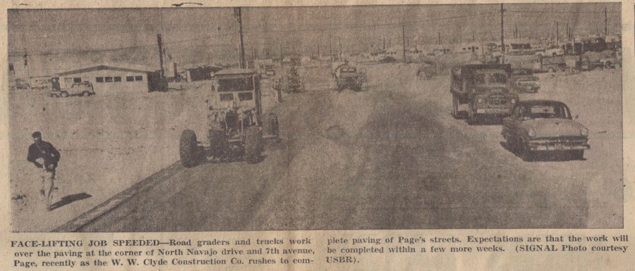
Photo Courtesy of the LeGate Family. Page Signal: 10-30-1958.
If my compass is correct, this is a look east along North Navajo and Seventh Avenue (now Lake Powell BLVD) is about where the photographer is located. You can see some of the early businesses and a little of the MCS trailer court in the top right of the photo. I talked about them in some previous posts. You can see a clearer picture of those first buildings —>HERE<—
Doctor Kazan was the happy recipient of Page’s 300th phone! You can see an Continue reading
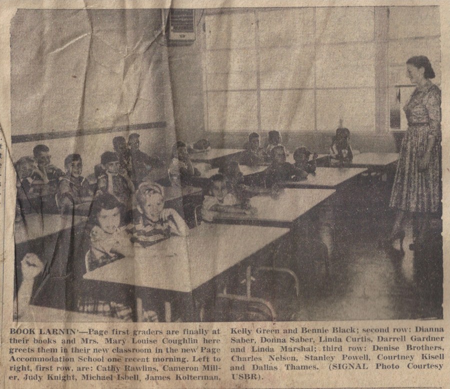
Gene LeGate loaned me a box of old Page Signal newspapers that I’ve been scanning as I have time. The Page Signal was Page’s first newspaper and pre-runner to The Lake Powell Chronicle. I’m scanning these old newspaper stories and pictures and will be posting them from time to time in a new category called A Day in the Life. Catchy, I know. 🙂 This first one is dated October 30, 1958.
Do you remember a post I did a while back called School Daze? I didn’t know it then, but the first two pictures in that post appeared in the Page Signal. To see that School Daze post, just click —>here<—. Here are the two pictures from the Signal. The captions gives us names. Pretty cool!
If you still have that School Daze post open, look at the second picture of the kids lined up by the old X and Y school buildings. Here it is again as it appeared in the Page Signal, complete with names.
Continue reading
Photo Courtesy of the LeGate Family. Undated.
Hey all, we’re on a road trip for the month of July but I wanted to stop long enough to get this amazing picture posted. This is my first post via email, so I hope it looks ok when posted. If not, I’ll tweak it later. Gene LeGate sent this pic to me a few days ago (thanks Gene!). I don’t know who took it, what building it was (it looks like one of the Butler Buildings used for the first school), where it was being moved to, or why. But here’s what I do know: it’s being moved away from town and it was a rainy day.
If you have some info about this picture and what was going on, please leave a comment. It seems like something like this would have drawn some attention.
In this post I want to share with you my remaining pictures of the first Page business district. I am indebted to Petey Lloyd Dietz, Ernie Severino Jr., and Terry Edwards for these pics. As a reminder, these businesses were located close to each other with the small shack businesses in a row along North Navajo Drive, and the building with the bank and Babbitt’s located just behind The Bottle Stop (now Stix Market). You can see exactly where they were in [this post]. Check these out…
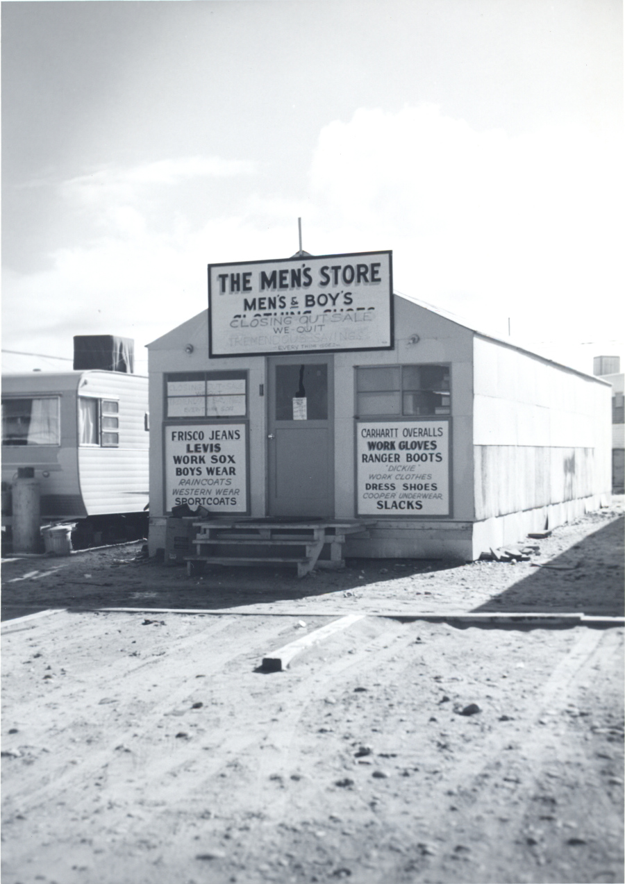
Photo Courtesy of Terry Edwards. Undated
The Men’s Store was going out of business when the above picture was taken. I’m not sure of the date. The strike of 1959 may have contributed to the decision to close. The picture below shows Grant Jones with a customer. I don’t know who the customer is or if it was taken inside the Men’s Store.
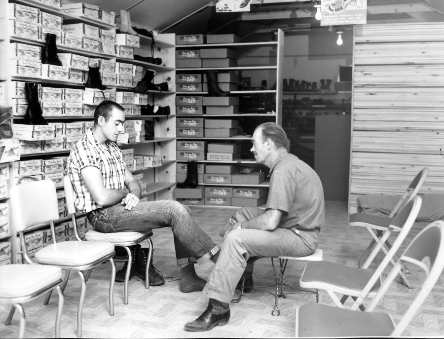
Photo Courtesy of Terry Edwards. Undated.
The photos below show the early businesses from different perspectives.
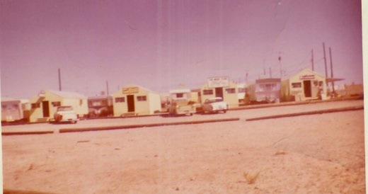
Photo Courtesy of Ernie Severino Jr. Undated.
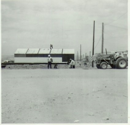
Warner’s Firestone building under construction. Photo Courtesy of Ernie Severino Jr. Undated.
Before we go any further, check out this picture of the bank, located in the same are:
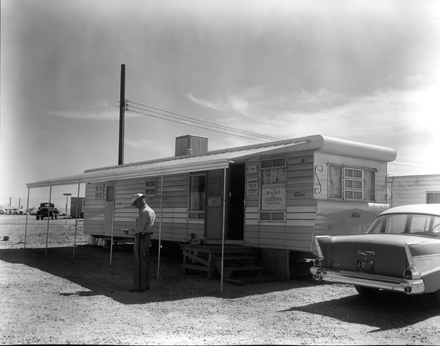
Photo Courtesy of Terry Edwards. Undated.
That looks pretty safe! As long as nobody drives off with it. I can’t make out who that is standing there. The street sign says B Street. The sign in the window just says The Bank of Arizona Page Office.
As you face these buildings, looking south from North Navajo, Babbitt’s and newer location of the Bank, were just off to the right, behind Continue reading
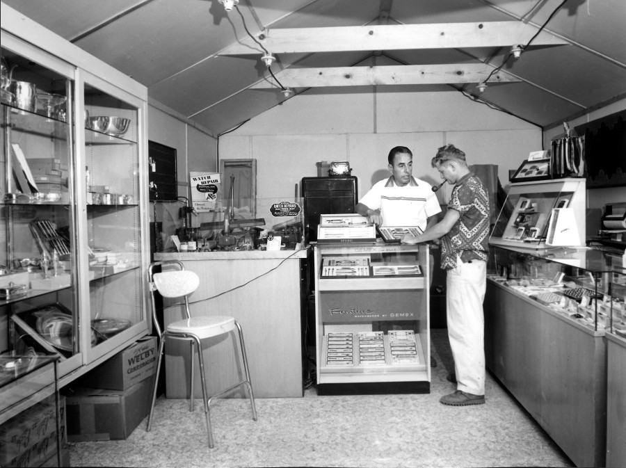
Photo Courtesy of Terry Edwards. Page Jewelers Original Store. Undated. Is the customer USBR photographer A. E. Turner?
Hey Peeps, I’m sorry it’s been so long since my last post. I guess I have a life after all. In my last post, way back in March, I promised my next few posts would be of the businesses in those small white buildings along North Navajo Drive. If you need a refresher, go back and read that post and then come back here.
In this post, we’re going to talk about Page Jewelers, one of those businesses. It was owned and run by Ernie Severino. The photo above shows him inside the original store located among other business trailers along North Navajo Drive. Does anyone recognize the customer? Is it USBR photographer A. E. Turner? Ernie Jr wrote me after I sent this picture to him and said,
“That chair is outside my shop, I use it all the time. I also see the machine that he used to clean watch parts, it’s in my shop too. Just can’t give it up!”
He gave me permission to share that with you. Thanks Ernie! He also gave me some good info on the layout of these businesses and the trailers there. He told me,
“At least that’s what we called them [The Shacks]. Starting at the left was our trailer, then Page Jewelers, and Kerry and Sonia Jones’ trailer, and then the shoe store, and then Bob Jorgenson’s (I’m pretty sure that was his name) trailer, and then his shop. The Men’s Store, and then the Firestone Store.
“There was a store next to our trailer, I think you mentioned it and said something about a Key Shop, I remember it as a place that sold carpet and floor covering it was owned by Bud Lippert. He had a son close to my age named Dennis.
“Then the next shack was Bill Lee’s restaurant I don’t know if it was called The Steak House at that point. I think it was a triple wide shack. It caught on fire during the middle of the night. A night I’ll never forget, luckily there was Continue reading
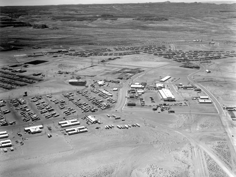
1959 Aerial View of Page, Arizona. Photo Courtesy of Terry Edwards.
Some of my favorite early pics of Page and the surrounding area are these old black and white aerial shots. You can see a lot of detail and they always bring back memories of what it was like. One of the reasons I’m posting this one is because in my next post or two, I’ll be highlighting some early businesses and I want you to have a reference point for their location if you’re not familiar with it.
We have a lot to talk about in this photo. Click on it to open it up and you’ll be able to zoom in. Let’s start on the right side, as you come into town on 7th Avenue. The Glen Canyon Steak House and Motel aren’t there yet, but it looks like the ground is being cleared for their construction. To the right, along Vista Ave., you get a good look at the Page Hospital and what was at that time, the USBR offices. You can see a close-up of that building and read more about it HERE. You can also see/read more about the hospital HERE. Okay, back to our journey up 7th Avenue. The next building on the left is the Page Boy Motel. The building across the street was the Vostron building and now houses the City of Page offices.
The building across from Vostron on this side of 7th Avenue is the bowling alley. The big rectangle building just this side of the bowling alley is the USBR warehouse. The white rectangle building to the left of the bowling alley in this photo was (is?) the fire station. The smaller building that’s attached to the right end of the fire station was the USBR Ranger station. The only thing I remember being in the Continue reading
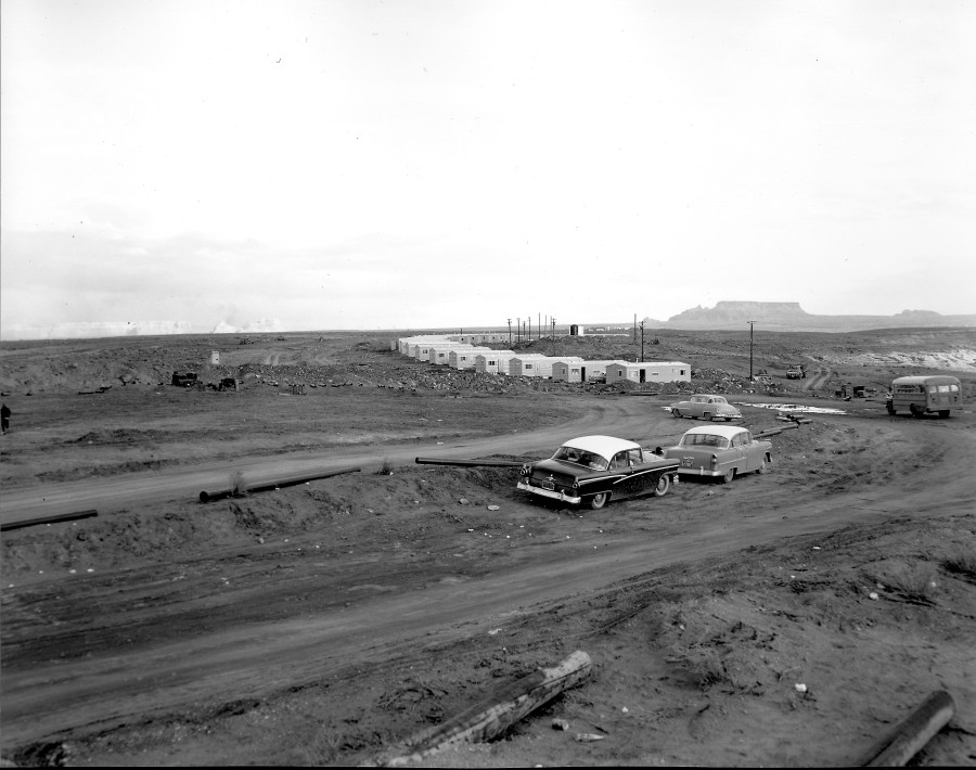
Photo: USBR. Undated. Photo Courtesy of Terry Edwards
Here’s an early shot of Page taken from the rim where North Navajo Drive and South Navajo Drive meet. Those are the Transit houses that dotted the rim along South Navajo and Aspen Street. As you can see, they are still being placed on site. The roads are being graded and the ground cleared. Notice the sewer pipe laying on the ground, awaiting installation. This photo is undated, but it has to be 1957 or 58. For comparison, look at the second picture I posted in the second blog on this site. It’s an aerial view showing the curve and the first airstrip which was about where this photographer was standing, along North Navajo. See it HERE.
Okay, back to this photo. There’s a school bus there because the Butler buildings were just to the right of this picture. They housed the first Page schools and they sat on the rim. You can see them in the link I provided above. I remember being told the water tank in the background of this picture was temporary while the town’s permanent water treatment plant was being built. I think that’s the water treatment plant being built in the far background. Did you know that the first water treatment plant for the town of Page was at the bottom of the canyon? It’s no doubt what supplied water to these tanks. See it HERE. Don’t miss the guy walking away on the left edge of the picture, as well as the outhouse. This picture provides a clear look at Le Chee on the horizon.
-Mike
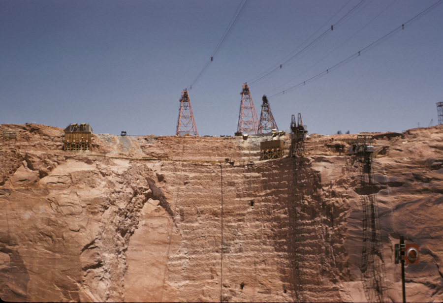
Here’s a great look at the left (Page side) key-way for Glen Canyon Dam. The key-ways were the vertical cut outs in the canyon walls where the dam was anchored into the rock. You can see two rectangle tunnels in the key-way and a third one to the right. I’m not sure what that third one was for, but there were a total of four of the other tunnels spaced along both key-ways. As the dam was built, these were connected to walkways inside the dam that ran the full length of the dam from edge to edge. There was instrumentation placed in those tunnels to measure stability and movement, and probably a lot of other things I’m not aware of. But having been inside at least one of them once the dam was finished, I remember how cold, wet, and eerie it was. I can also still remember the smell – like wet concrete. But I digress.
The towers above were the mobile cranes that rode along tracks and could move back and forth to move materials, people, and dump concrete buckets during the construction of the dam. There were three more on the opposite side of the canyon, behind the photographer. On the right side of the key-way is an elevator that ran on vertical rails up and down the canyon wall. I remember watching that thing from the bridge as it shuffled people in and out of the canyon. It seems like there was another smaller one to the right of that one, but it’s all a blur. I’m not sure what the wooden structures at the top of the key-way were.
Enjoy,
-Mike

