From my archives. Undated and source unknown.
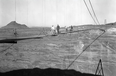
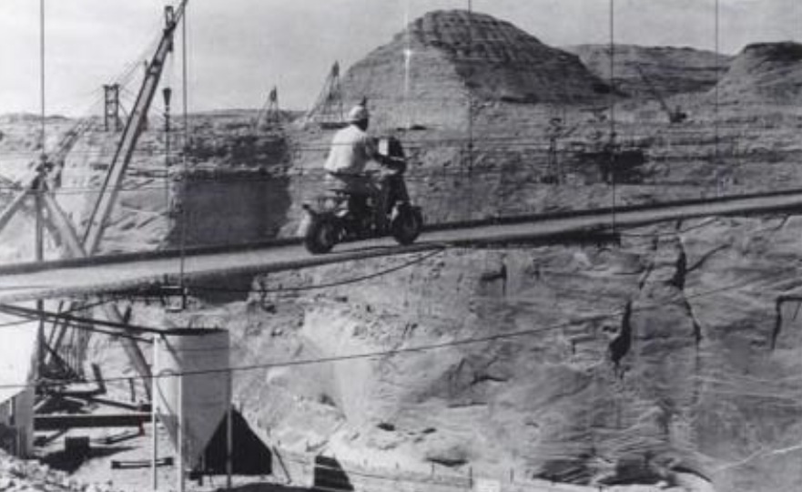
Here’s a little something to take into your weekend. Remember, always wear a helmet. Especially if you’re crossing a footbridge 700+ feet above a canyon floor, with minimal or no side rails.
-Mike
From my archives. Undated and source unknown.
Here’s a little something to take into your weekend. Remember, always wear a helmet. Especially if you’re crossing a footbridge 700+ feet above a canyon floor, with minimal or no side rails.
-Mike
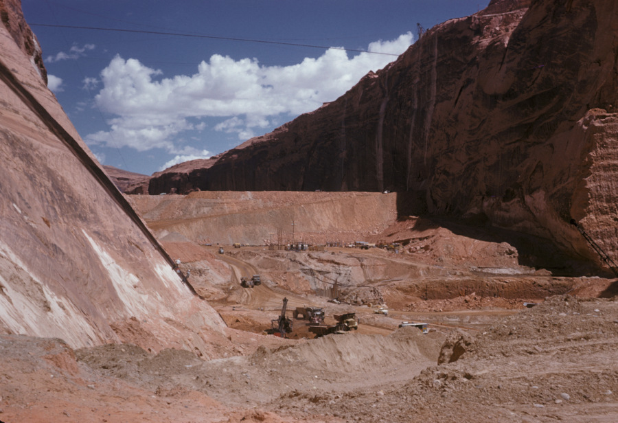
Photo: USBR. July, 1959. Courtesy of Terry Edwards.
I love the detail in these old USBR photos. If you zoom in on them, you can see some pretty cool stuff. This one is no exception. It gives us a good downstream look at the temporary coffer dam. You are looking upstream toward what would eventually become Lake Powell. The coffer dam was built to divert the Colorado River water into the two spillway tunnels that routed the water through the canyon walls to the downstream side of the dam site. The right side tunnel (the Visitor Center side) was the primary tunnel and it handled most of the diversion water.
The excavation going on in this picture is prep work for laying the base of the dam. I remember reading or hearing somewhere that the base concrete for Glen Canyon Dam was poured 135 feet below bedrock. This picture captures that excavation. Some of the dirt and rock that was Continue reading
This video has some excellent shots of the construction of Glen Canyon Dam. It’s part 2 of a 5-part series by Gary Ladd in what looks like a lecture at NAU. I put all 5 parts on a new video page. Click the Videos tab above to get there, or just click HERE.
Enjoy… Mike

Photo: USBR. Courtesy of Terry Edwards. Undated
This first picture is a great look inside an elementary class in the old X and Y buildings. These were the temporary buildings that were built across from the Catholic Church, but I think they pre-dated that church. Maybe you were in this picture. If so, leave a comment and let me know. This teacher looks familiar, but I don’t have a name to go with the face. I remember those light fixtures and the heaters in the corner, hanging from the ceiling. The boy and girl closest to the photographer look pretty chummy. 😉 These pictures are undated, but have to be early 60s.

Photo: USBR. Courtesy of Terry Edwards. Undated
The photo above is an outdoor shot taken from the east-ish end of the buildings, looking west. 7th Avenue (Lake Powell BLVD) and the Catholic Church are to the left of this picture. Are you in this, or do you recognize Continue reading

Have you guys seen this yet? It’s a link to the Page High and Junior High yearbooks, beginning in 1960. You can scroll through the pages. This is a great way to look back if you no longer have the yearbooks. Just pick the year you want to look at from the drop-down selector. The one in the link will take you to 1960. From there, you can select others. Enjoy!
-Mike
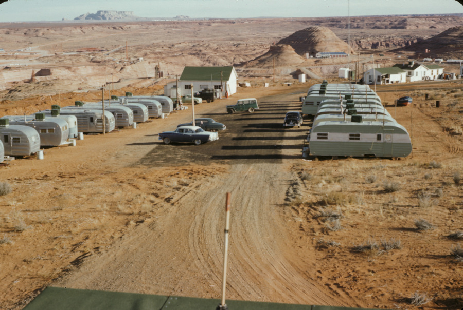
This is a great shot of a temporary trailer park at the Glen Canyon Dam construction site. I don’t have any information about when it was built, why, or how long it was there. I do know it was temporary because it sits on part of the spot where the conveyor belts for delivering the aggregate to the batch plant were eventually built. They would have been just to the right of this picture, and probably would have extended into the picture a little.
It’s a good look at the Beehive from the north. It doesn’t look like the canyon side of the Beehive has been removed yet, but it’s hard to tell. The bridge isn’t there yet, but construction is underway. On the left side of the picture, you can see the top of the left spillway. Also, along the highway, that large building that was used as some kind of laydown yard is framed, but not finished yet. If you zoom in, you can see the water tower in town. It’s also a good shot of LeChee. The buildings on the left side of Manson Mesa may be the corals and drive-in theater.
Ok, back to the trailer park. Does anyone know what the white buildings were? I’d give good money for the Willy’s jeep. The boat without a trailer is classy. Enjoy!
-Mike
I have to admit to not remembering Page’s first water treatment plant being at the bottom of the canyon. When Gene LeGate gave me the first bunch of USBR photos for the blog and I saw these water treatment pics, I was dazed and confused because I could only remember the water treatment plant in town and those photos were completely different. After some research, I surmised that it sat downstream of the dam on the Page side of the canyon. Can’t fool me! What sealed it for me (sort of) was the first photo I’m sharing below that Tim McDaniels gave me that shows the road to it coming out of what must be one of the adits in the canyon wall that now serves as one of the ventilation tunnels for the tunnel that runs from the top of the canyon and to the lower spillway. If that’s incorrect, please let me know. I can take it. I’m still not 100% convinced because some of the background stuff in these pictures doesn’t look right. More on that as we move through them.
This first picture is a shot from above showing the layout of the area. This is the one Tim sent me that pretty much clinched the location. Notice the water line coming over the side of the canyon. That’s the line that brought water to the fledgling town of Page. It’s referenced in another picture below. Notice also the road disappearing into the canyon wall. The handwritten caption on the back reads, “J. Reinhold. 1st water treatment plant for Page.”

Here’s another top down view from a different, closer angle. In this shot, the facility is still under construction. The rectangle building was an electrical switchgear and maybe a pump room. The handwritten back caption reads, “Water pumps and sedimentary tank on river below Page.”
Continue reading
The transit homes were scattered along the rim of South Navajo Drive and Aspen Street. Even though these photos are black and white, these tiny houses made a bold statement all their own in their hot pinkish paint jobs. I’ve heard these referred to as transa homes too, but I’m sticking with transit. I hope that doesn’t drive any of you away, or to drinking. In a previous post, I mentioned these homes and you can see an aerial shot of them by clicking >>HERE<<.
This first picture is one of my favorites. The quality and detail are amazing. I’ll say a couple things about it underneath it. I give you…. the transit homes….
It looks like a serene winter day. And there just happens to be a 57 Chevy sitting there. No offense to the Rambler of course. This shot was taken looking along South Navajo Drive. In the background, you can see the houses continue along Aspen Street. Notice the dirt (sand) road and sidewalk. In the distance you can see the old X and Y school buildings and the Catholic Church. Behind that is the water tower. To the left of the X and Y buildings is the Southern Baptist Church and LeChee. The white rooftop in front of LeChee may be the Episcopal Church, but I’ve been wrong before. The building on the far left of the photo is the edge of the school D building, which would have been newly constructed about this time. Here’s another view…

I’m not sure if this one was taken along South Navajo or Aspen Street. But the large tank in the background that’s peeking over the roof of the closest home, caught me by surprise. I’m not sure what that was. This may have been taken the same day as the first picture. It was taken during the colder months, or the evap coolers would have been uncovered. Check out the 3rd home down the row. That round, white thing almost looks like a satellite dish! LOL.
-Mike
Tim McDaniels, this one’s for you. Just when I thought there weren’t any more. I hope this helps.