Photo: J. L. Digby, USBR 10/6/1958 Courtesy of the Legate Family
I appreciate the clean look of this photo, dated October 6, 1958. The handwritten back caption reads, “Municiple buildings where big cheeses from Bureau work.” If you live in, or have lived in Page for any length of time, you probably recognized this building right away. It sits on the corner of North Navajo Drive and Vista Avenue. If you type Page Arizona into Google Earth and go to that intersection, you’ll get a good look at how it appears today.
In addition to the USBR administrative offices, this building has also been the Page Municiple building and courthouse and the National Park Service headquarters. I seem to remember the library being in there too, but I may be having a senior moment. Can somebody help out a brother here? If you remember, let me know.
The fact that there is no other development anywhere in this picture makes it that much better. I like that North Navajo Drive is still dirt. Vista Avenue is to the right in this picture and today, the Page hospital sits across the street (Vista Ave) to the right of the photo. Did I mention that I like the pickup truck on the far right side?
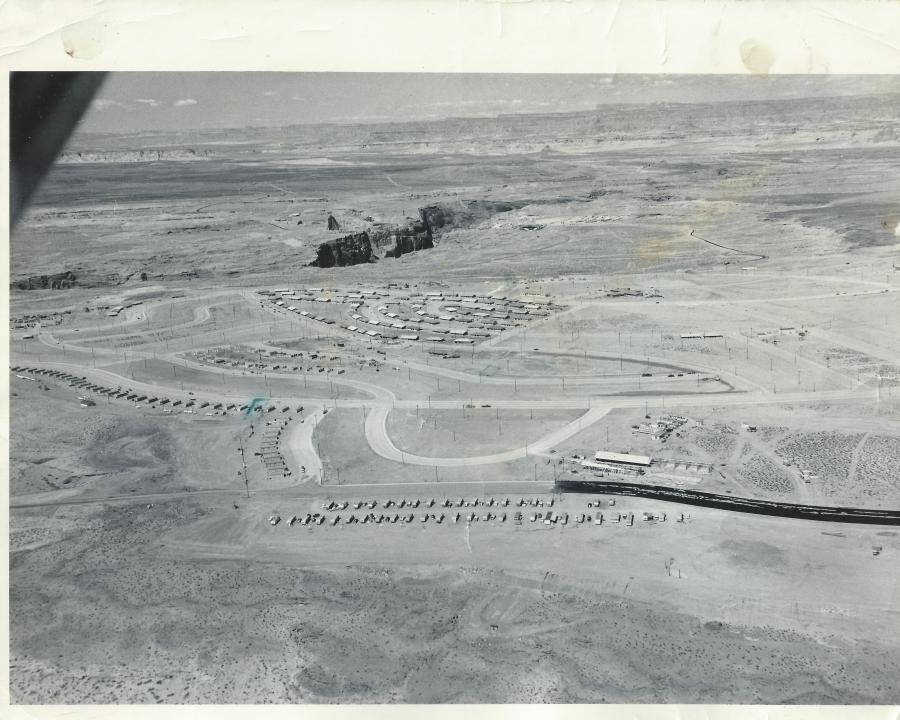
Page Arizona, 1957-58. Source: USBR. Photo courtesy of the LeGate Family
This fantastic aerial shot of Page is undated, but I think it’s safe to place it in the 1957-58 time frame. The original photo is an 8×10 with the following hand written on the back by Gene C. Legate (unedited),
“Gov’t houses under construction. Ours [Legate’s] is 4th house from right end of the line of houses which extend from middle of picture to left toward middle of picture. Other place marked is where we’ll move to shortly. Black road is fresh oil which is put on before asphalt is placed on it. The first 100 houses shown are near completion. The second 100 are now about finished and are in the two blocks below first 100. Dam site in exposed canyon. Temporary school at lower right under construction.”
There is a lot going on in this picture that I would like to talk about. Let’s start at the bottom of the picture. I don’t remember the two lines of mobile homes at the bottom along 7th Avenue (now Lake Powell Blvd), but they are sitting on the approximate location of the Catholic Church. I think there’s a tennis court there now too. The temporary school buildings across the street from the mobile homes referenced on the back of the picture, became the X and Y buildings where I started 1st grade in Mrs. Frye’s class. I have a street-level picture of those buildings, and a story to share with you at a later date. The circular road next to the X and Y buildings was the drive through where buses and parents would drop their kids off for school. I remember it well. That road’s been gone a long time and is now baseball fields, I believe. The high school football homecoming bonfires used to be held in that area.
The row of buildings along the street next to the drop-off loop, that continue on to South Navajo Drive, were the transit (transa?) houses. I think these were originally put there as temporary housing for some of the USBR employees. Someone help me out here if you have more info for us. What I do remember is that they were a bright pink color and they were there for years. Do you see the green pen mark next to the 4th one along Navajo Drive? That is the one referenced in the description on the back of the picture as being where the LeGate family lived for a time. It’s hard to see, but if you enlarge the picture, you’ll see a green square drawn on Cedar Street, also referenced on the back of the picture as “the place…we’ll move to shortly.”
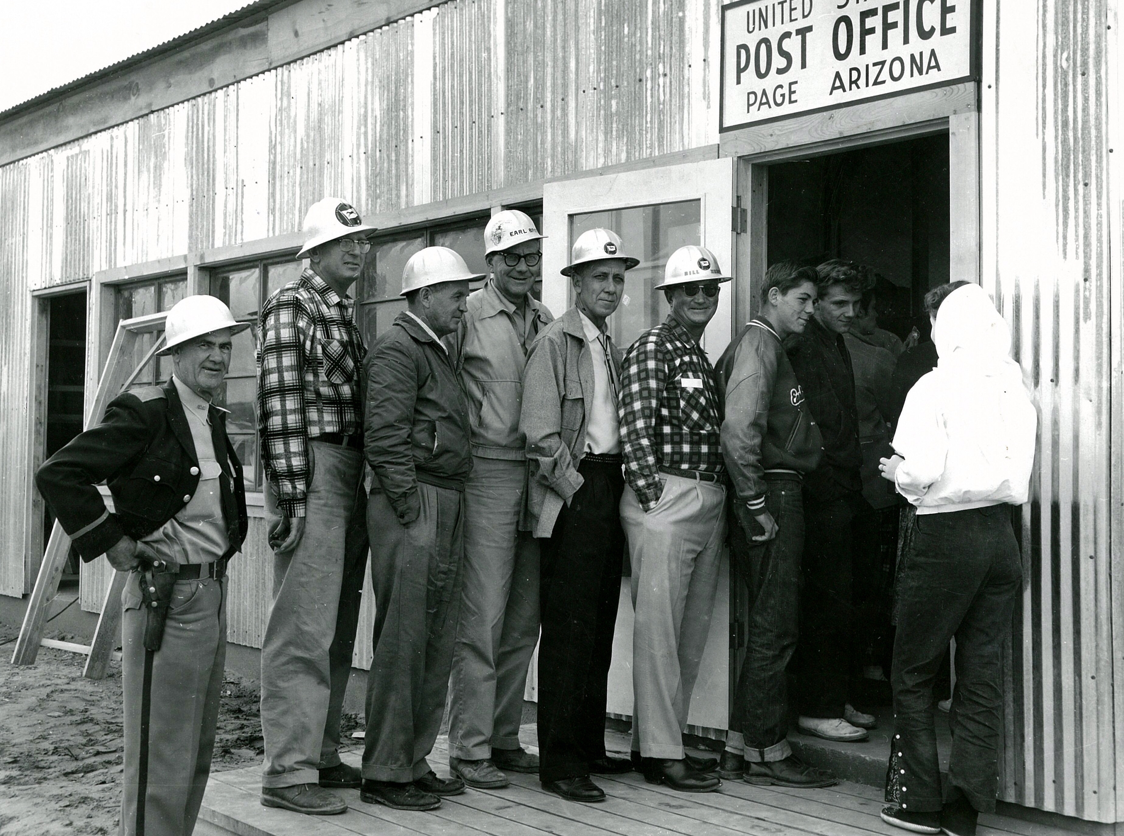
Page Arizona Post Office 1958. Source: LeGate Family
This amazing picture was sent to me yesterday by a friend (thank you Gene!). I don’t know who took it or why, but it’s one of my favorites. It’s the Page Post Office in 1958. This was taken 1 1/2 to 2 years before we moved there and I don’t recognize anyone in it. I think it’s interesting that the young guys are talking to the girl, but the older guys are all about the camera, except that one guy. There’s always that one guy.
This building was located next to the USBR warehouse on North Navajo. across the street from present day Stromboli’s. I am curious to know why there was such a line out the door on this day. Nobody seems to have anything to mail. Maybe it was a rush on forever stamps or maybe there was free wifi. But I doubt it.
I found a copy of the 1973 Yellow Pages so I have a new category to post these ads in. I’ll be posting these old ads from time to time.
I’m posting this one first because it’s special. First, it reads, “Add a Page to your trip.” I’m relieved to see I’m not the only one who read that old sign. If you’re wondering what I mean, check out my first post, Add a Page To Your Trip.
Another reason I’m posting this one first is because it was one of my first full-time jobs. Yours Truly was one of the truck drivers that picked up and delivered laundry to the boarding schools on the reservation and brought it back here to be laundered. I worked for Al and Sandy. They were great people. I wonder if they’re still in Page?
But the big reason I’m posting this ad first is because I lived here for a while. Yes, it’s true. I lived at the laundromat. At least my clothes were always clean. Drive down to Vista Avenue and check this place out. It’s kind of an “L” shaped building with the corner of the “L” built out toward Vista Avenue. That was my apartment. Initially, it was a beauty salon, but eventually became my home sweet home in 1972ish for several months.
I wish this picture was bigger. When I try to enlarge it, it gets blurry. This is the Pink Sans Drive-in circa 1961. It was (and still is) located on 7th Avenue (now Lake Powell BLVD) across from the park. More precisely, it was located across the street from the pool at the park. Yes, there used to be a good sized town pool at the corner of South Navajo Drive and 7th Avenue. I spent many summer days there.
This is the way I remember the Pink Sans looking. It was all outside, covered seating with picnic style tables. Just to the right of this picture was the Chevron gas station and on the other side (in the direction the camera is pointing) was the old Sportsman’s Headquarters. It eventually became a laundromat and after that, who knows. I don’t know what’s there today.
The Pink Sans was like Al’s Diner on Happy Days. It was the place to hang out, so we did. I remember watching occasional high school drag races down 7th Avenue. The Pink Sans was the starting line for those races and it seems like First National Bank, on the corner of Elm and 7th Avenue, was the finish line. There were no traffic signals back then, and evidently, not much traffic either! I’m not sure where the police (they were called Rangers back then) were, but I don’t remember ever seeing any when someone decided to race.
When I hit high school, we usually walked to the Pink Sans to grab a deep fried burrito from Sue, who always seemed to be working there at lunch, followed by some kind of Hostess treat for 13 cents at the Sportsman’s Headquarters next door. Ah the good ‘ole days!
This aerial shot from 1960 or 61 shows the newly completed school buildings along South Navajo Drive at the intersections of Date Street and 5th Avenue. You can see a few church buildings springing up on church row at the top of the picture. Originally, that was called 7th Avenue but was renamed to Lake Powell Blvd a number of years ago. The teacher’s apartments are the long buildings on this side of 7th avenue. They’re no longer there. I guess someone thought it would be a good idea to round up all of the teachers and keep them in one spot for easy handling. Probably not a bad idea. Ha!
Ok, back to the picture. The oval shaped area on the left side of the picture is the football field and track. The bleachers are the small strip next to the field. I have a cool ground shot of the field and scoreboard that I’ll be posting soon. The area behind the bleachers was little more than a big sand pit used for football practice. I remember running wind sprints in full pads in that sand that seemed to be 4 feet deep. I get winded just thinking about it now.
I don’t know how these buildings are referred to now, but they were originally labeled by letter. The larger building on the left was A Building. The small one next to it was B Building (I know, pretty creative!). Both of these building housed the high school. The large building in the middle was the Gym (C Building) and the long one near the bottom was D Building. D Building was home to the junior high-ers and I think down to 3rd or 4th grade originally. I was in D Building when President Kennedy was shot. I was in 3rd grade, so it must have gone that low. What’s not shown in this picture is the old X and Y buildings that housed the 1st and 2nd grades for a few years. Those were to the right of this picture along 7th Avenue across from the Catholic Church. X and Y Buildings were long, temporary, wooden buildings where I started 1st grade. At the bottom of D Building, you’ll see a small fenced-in concrete slab that was called the playpen. We spent recesses out there playing anything we could play with a ball.
If I remember right, the square area just above the gym was blacktop. There must have been basketball posts there, but my memory of it is pretty sketchy. Cedar Street is just off the picture on the bottom left corner. Those two houses there are facing Cedar Street. We lived in the 2nd or 3rd house from Date Street on the north side of Cedar Street for a time. I remember listening to Beatles 45 records in the front yard.
It looks like there is still some construction going on with the Bureau homes in this picture, at least in the back yards and easement. The sand was always horrible during windy days and getting it under control seemed to be a constant battle. Check out the row of small trees there were planted in the front yards along South Navajo.
Does anyone else remember the school crossing guards that worked that corner of Date and South Navajo? They were older school kids who got to wear uniforms and carry big flags. When we got to the corner and needed to cross, they would lower those big flags to a 45 degree angle and walk out ahead of us to stop traffic (one on each side of Navajo Drive). I remember thinking how cool that was I wanted so bad to become a crossing guard. I wish I had a picture of them to show you.
For comparison, here’s an aerial view of the same spot today:
Does this building look familiar to my Page friends? It’s the old Green Thumb Nursery and the building that housed it was (is) located at 810 N. Navajo Drive. I don’t remember who owned it or who ran it, but I do remember peering in those windows a lot. If you can help add some background to this, please jump into the conversation and let me know.
This building eventually housed a fix-it/small appliance shop that always reminded me of Emmit’s Fix-it shop from the old Andy Griffith show. I don’t remember the name of that business but it may have been run by the Dolands. That sticks in my mind for some reason. Maybe Mrs. Doland just worked there, but I seem to remember her in there a lot. They also owned/ran the movie theater and Doland’s Curios Shop, which was located a couple of doors down from the theater. But I digress…
It seems like it sat closed for quite a while, but it eventually became Bella Napoli Italian Restaurant. No wonder I always liked their salads! Today, I think it’s called Bonkers. By the way, is that a Buick sticking its nose in the left side of this picture? It might be. Our family had one with that body style. If that’s a Buick, I’m not saying it was ours, but it could have been. Just sayin’. I’d sure take that pickup in a heartbeat though. And that VW bus would look real good in my garage!
Speaking of VW busses, here’s a shot of yours truly in 1974 filling up my bus at Specht’s gas station and car wash. This was located next door the Green Thumb Nursery building, across the street from what would one day be Stromboli’s. I don’t think Specht’s is there anymore, but if I’m wrong, let me know.
-Mike
Yours Truly with my VW bus in 1974. Photo: Susan Adams
The 3 Butler Buildings that housed Page schools in the late 1950s
These are the Butler buildings that served as the Page schools from 1958-1959 or 60. The permanent school was under construction and completed about 1960. These three buildings were located on the curve of South Navajo Drive. You can get a better feel for where they were located by looking at the bottom center of the aerial picture I posted [here].
The permanent school buildings were completed in 1959-60 and are located on South Navajo Drive, across from the Date Street intersection. These were originally called the A, B, C (Gym), and D buildings.
Yes, this is cool. This shot of the early Page business district is a sweet pic. I like the Firestone sign that reads, “Changeover to New Firestone Tubeless Tires Now!” Tubeless tires. What a concept, but I doubt it will catch on. lol. In addition to Firestone, you can see Page Jewelers (my mom worked there after it was moved to 7th Ave), and a locksmith shop. I can’t make out the two businesses in the middle. Maybe one of you can tell us what they were. Anybody? I’m diggin’ the cars though.
This business district was located on the corner of present day Aero Drive and N. Navajo Drive. It was between N. Navajo and present day Cathedral Drive, across the street from present day Fred’s Liquor.
If you scroll down and look at my previous post of the Froze in Time aerial shot, you’ll see an outcropping of buildings along 7th Avenue (present day Lake Powell Blvd). Babbitt’s and First National Bank of AZ occupied those buildings. That picture may have been taken before those businesses moved in, but they eventually found a temporary home there. I have some photos I’ll be sharing with you that show that.